
Delwedd:PIA15696-HiRISE-MSL-Sol11 2 -br2.jpg

Maint llawn ((1,024 × 658 picsel, maint y ffeil: 110 KB, ffurf MIME: image/jpeg))
Crynodeb
| Disgrifiad |
English: 08.31.2012
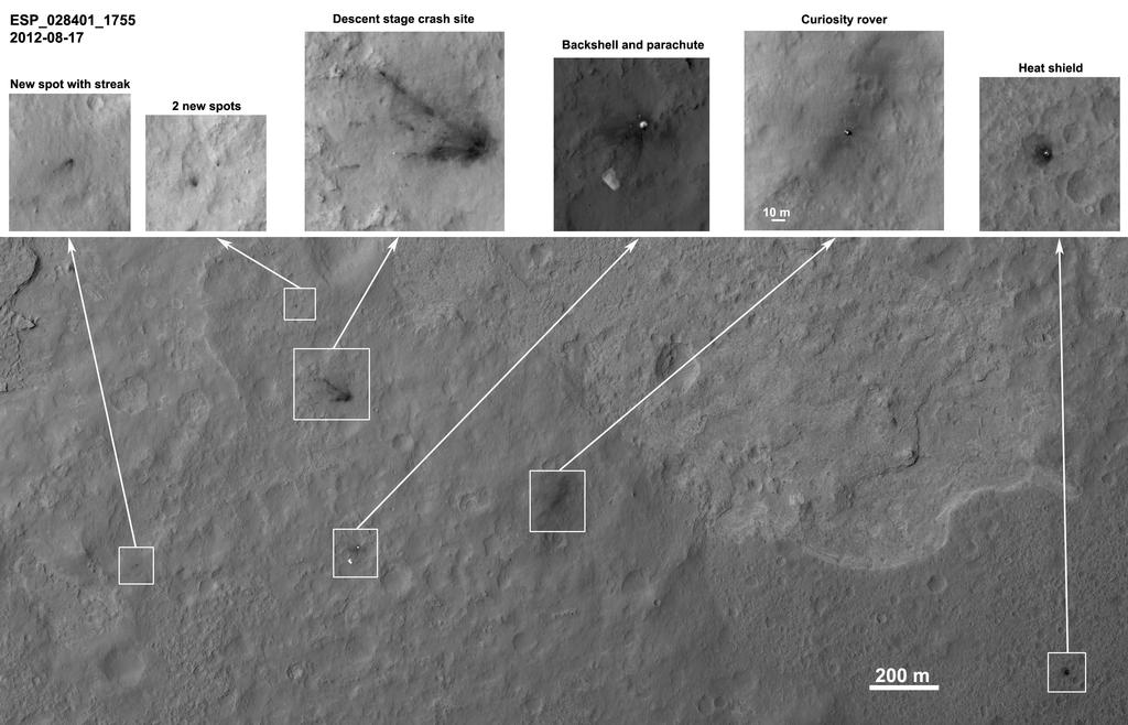
Orbiter View of Curiosity From Nearly Straight Overhead Details such as the shadow of the mast on NASA's Mars rover Curiosity appear in an image taken Aug. 17, 2012, by the High Resolution Imaging Science Experiment (HiRISE) camera on NASA's Mars Reconnaissance Orbiter, from more directly overhead than previous HiRISE images of Curiosity. In this product, cutouts showing the rover and other hardware or ground markings from the landing of the Mars Science Laboratory spacecraft are presented across the top of a larger, quarter-resolution overview keyed to the full-resolution cutouts. North is up. The scale bar is 200 meters (one-eighth of a mile). Curiosity landed Aug. 5, PDT (Aug. 6, EDT). HiRISE imaged the spacecraft during its descent [1], on the first day after landing [2] and on the sixth day after landing [3]. This image was acquired looking more directly down (9 degree roll angle) than the prior images so the pixel scale is improved to approximately 11 inches (27 centimeters) per pixel. Each cutout is individually stretched to best show the information without saturation. A special noise cleaning method was applied to the images by Paul Geissler of U.S. Geological Survey. The shadow of Curiosity's mast extends southeast from the rover, opposite the solar illumination direction. Dark spots on the left-side cutouts created streaks radial to the descent-stage impact site. They may be from far-flung rocks or objects associated with the impact. Seven bright spots associated with the descent stage crash site, as well, may be pieces of hardware. There are also bright pieces scattered around the backshell, mostly downrange, and interesting detail in the parachute. The rover is approximately 4,900 feet (1,500 meters) away from the heat shield, about 2,020 feet (615 meters) away from the parachute and back shell, and approximately 2,100 feet (650 meters) away from the discoloration consistent with the impact of the sky crane. Other products from the same HiRISE observation can be found at http://www.uahirise.org/ESP_028401_1755 . HiRISE is one of six instruments on NASA's Mars Reconnaissance Orbiter. The University of Arizona, Tucson, operates the orbiter's HiRISE camera, which was built by Ball Aerospace & Technologies Corp., Boulder, Colo. NASA's Jet Propulsion Laboratory, a division of the California Institute of Technology in Pasadena, manages the Mars Reconnaissance Orbiter Project for NASA's Science Mission Directorate, Washington. Lockheed Martin Space Systems, Denver, built the spacecraft. Image Credit: NASA/JPL-Caltech/Univ. of Arizona/USGS |
| Dyddiad | |
| Ffynhonnell | http://mars.jpl.nasa.gov/msl/images/PIA15696-HiRISE-MSL-Sol11__2_-br2.jpg |
| Awdur | http://mars.jpl.nasa.gov/msl/images/PIA15696-HiRISE-MSL-Sol11__2_-br2.jpg |
Trwyddedu
| This file is in the public domain in the United States because it was solely created by NASA. NASA copyright policy states that "NASA material is not protected by copyright unless noted". (See Template:PD-USGov, NASA copyright policy page or JPL Image Use Policy.) | ||
 |
Warnings:
|
Hanes y ffeil
Cliciwch ar ddyddiad / amser i weld y ffeil fel ag yr oedd bryd hynny.
| Dyddiad / Amser | Bawdlun | Hyd a lled | Defnyddiwr | Sylw | |
|---|---|---|---|---|---|
| cyfredol | 17:41, 31 Awst 2012 | | 1,024 × 658 (110 KB) | Drbogdan | User created page with UploadWizard |
Cysylltiadau'r ffeil
Mae'r 1 tudalennau a ddefnyddir isod yn cysylltu i'r ddelwedd hon:
Defnydd cydwici y ffeil
Mae'r wicis eraill hyn yn defnyddio'r ffeil hon:
- Y defnydd ar bg.wikipedia.org
- Y defnydd ar bn.wikipedia.org
- Y defnydd ar ca.wikipedia.org
- Y defnydd ar en.wikipedia.org
- Y defnydd ar es.wikipedia.org
- Y defnydd ar fa.wikipedia.org
- Y defnydd ar it.wikipedia.org
- Y defnydd ar ja.wikipedia.org
- Y defnydd ar ko.wikipedia.org
- Y defnydd ar sr.wikipedia.org
- Y defnydd ar test.wikipedia.org
- Y defnydd ar tr.wikipedia.org
- Y defnydd ar uk.wikipedia.org
- Y defnydd ar zh.wikipedia.org