
Delwedd:On Top of the World (wallpaper).jpg

Maint llawn ((1,920 × 1,200 picsel, maint y ffeil: 1,023 KB, ffurf MIME: image/jpeg))
.jpg)
Crynodeb
| Disgrifiad |
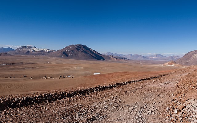
English: Some places on Earth can seem like alien environments, as this stunning panorama shows. It is not the strange surface of an exoplanet, but rather the Chajnantor Plateau in the Chilean Andes. This unearthly location is home to ALMA, the Atacama Large Millimeter/submillimeter Array. Chajnantor was chosen because the rarefied atmosphere above this very high site is so dry that, unlike at most other places on Earth, it is largely transparent to the wavelengths of light that ALMA is designed to detect.
At the centre of the image, the darker, rounded shape of the peak of Cerro Chajnantor, 5600 metres high, can be spotted, followed slightly to the left in the far distance by the conical shape of the 5930-metre Licancabur volcano. The flat area in front, at an altitude of 5000 metres, is the Chajnantor Plateau, the ALMA Array Operations Site. Here the 66 ALMA antennas can be arranged in different configurations, where the maximum distance between antennas can vary from 150 metres to 16 kilometres. The clustered white peaks on the right in the foreground are penitentes, formed by the sublimation of snow in an extremely high altitude and very dry environment. This area of the Chilean Andes borders Bolivia and Argentina. ALMA will give astronomers an unprecedented window on the cosmos, enabling groundbreaking studies into areas such as the physics of the cold Universe, the first stars and galaxies, and even directly imaging the formation of planets. ALMA, which will begin scientific observations in 2011, is the largest astronomical project in existence and is a truly global partnership between the scientific communities of East Asia, Europe and North America with Chile. ESO is the European partner in ALMA. An amazing interactive virtual tour of Chajnantor is available at http://www.eso.org/public/outreach/products/virtualtours/chajnantor.html |
||||
| Dyddiad | |||||
| Ffynhonnell | http://www.eso.org/public/images/potw1116a/ | ||||
| Awdur | ESO | ||||
| Caniatâd (Ailddefnyddio'r ffeil hon) |
|
||||
| Camera location | | View this and other nearby images on: OpenStreetMap |
|---|
.jpg¶ms=-23.066667_N_-067.750000_E_globe:Earth_type:camera_heading:0.00_region:CL-AN&language=cy)
| Annotations | This image is annotated: View the annotations at Commons |
Hanes y ffeil
Cliciwch ar ddyddiad / amser i weld y ffeil fel ag yr oedd bryd hynny.
| Dyddiad / Amser | Bawdlun | Hyd a lled | Defnyddiwr | Sylw | |
|---|---|---|---|---|---|
| cyfredol | 16:45, 5 Mawrth 2013 | | 1,920 × 1,200 (1,023 KB) | Stas1995 | User created page with UploadWizard |
Cysylltiadau'r ffeil
Mae'r 1 tudalennau a ddefnyddir isod yn cysylltu i'r ddelwedd hon:
Defnydd cydwici y ffeil
Mae'r wicis eraill hyn yn defnyddio'r ffeil hon:
- Y defnydd ar en.wikipedia.org
- Y defnydd ar fr.wikipedia.org
- Y defnydd ar gu.wikipedia.org
- Y defnydd ar sw.wikipedia.org
- Y defnydd ar te.wikipedia.org
- Y defnydd ar uk.wikipedia.org
- Y defnydd ar ur.wikipedia.org
.jpg)