
Delwedd:Mountain Fork Bridge.jpg

Maint y rhagolwg: 471 × 599 picsel. Eglurdebau eraill: 189 × 240 picsel | 377 × 480 picsel | 604 × 768 picsel | 805 × 1,024 picsel | 1,611 × 2,048 picsel | 3,691 × 4,693 picsel.
Maint llawn ((3,691 × 4,693 picsel, maint y ffeil: 1.61 MB, ffurf MIME: image/jpeg))
|
This is an image of a place or building that is listed on the National Register of Historic Places in the United States of America. Its reference number is 90000540. |
| Camera location | | View this and other nearby images on: OpenStreetMap |
|---|
| Disgrifiad |
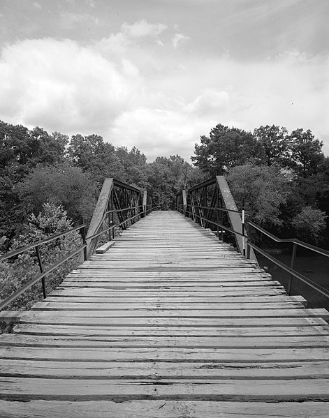
English: Looking west on the Mountain Fork Bridge, which carries County Road 38 over Mountain Fork Creek near Mena in Saline County, Arkansas, United States. Built in 1926, this Pratt pony truss bridge is listed on the National Register of Historic Places. |
||||
| Dyddiad | |||||
| Ffynhonnell | Library of Congress, Prints and Photograph Division HAER: ARK,57-CAPI.V,1-3 | ||||
| Awdur | Jeff Holder | ||||
| Caniatâd (Ailddefnyddio'r ffeil hon) |
|

|
This image is available from the United States Library of Congress's Prints and Photographs division
under the digital ID hhh.ar0092. This tag does not indicate the copyright status of the attached work. A normal copyright tag is still required. See Commons:Licensing.
|
Hanes y ffeil
Cliciwch ar ddyddiad / amser i weld y ffeil fel ag yr oedd bryd hynny.
| Dyddiad / Amser | Bawdlun | Hyd a lled | Defnyddiwr | Sylw | |
|---|---|---|---|---|---|
| cyfredol | 02:03, 13 Rhagfyr 2009 | | 3,691 × 4,693 (1.61 MB) | Nyttend | {{Location|34|31|41|N|94|24|0|W}} {{Information |Description={{en|Looking west on the {{w|Mountain Fork Bridge}}, which carries County Road 38 over Mountain Fork Creek near {{w|Mena, Arkansas|Mena}} in {{w|Saline County, Arkansas|Saline County}}, {{w|Arka |
Cysylltiadau'r ffeil
Mae'r 1 tudalennau a ddefnyddir isod yn cysylltu i'r ddelwedd hon:
Defnydd cydwici y ffeil
Mae'r wicis eraill hyn yn defnyddio'r ffeil hon:
- Y defnydd ar ar.wikipedia.org
- Y defnydd ar ceb.wikipedia.org
- Y defnydd ar ce.wikipedia.org
- Y defnydd ar en.wikipedia.org
- Y defnydd ar es.wikipedia.org
- Y defnydd ar fr.wikipedia.org
- Y defnydd ar ga.wikipedia.org
- Y defnydd ar hu.wikipedia.org
- Y defnydd ar hy.wikipedia.org
- Y defnydd ar ki.wikipedia.org
- Y defnydd ar no.wikipedia.org
- Y defnydd ar pl.wikipedia.org
- Y defnydd ar ru.wikipedia.org
- Y defnydd ar sr.wikipedia.org
- Y defnydd ar tt.wikipedia.org
- Y defnydd ar ur.wikipedia.org
- Y defnydd ar www.wikidata.org
- Y defnydd ar zh-min-nan.wikipedia.org