
Delwedd:MonticolaSaxatilisIUCNver2019 1.png

Maint y rhagolwg: 800 × 566 picsel. Eglurdebau eraill: 320 × 226 picsel | 640 × 453 picsel | 1,024 × 724 picsel | 1,280 × 905 picsel | 2,560 × 1,810 picsel | 3,507 × 2,480 picsel.
Maint llawn ((3,507 × 2,480 picsel, maint y ffeil: 940 KB, ffurf MIME: image/png))

|
File:MonticolaSaxatilisIUCN.svg is a vector version of this file. It should be used in place of this PNG file when not inferior.
File:MonticolaSaxatilisIUCNver2019 1.png → File:MonticolaSaxatilisIUCN.svg
For more information, see Help:SVG. |
 |
Crynodeb
| Disgrifiad |
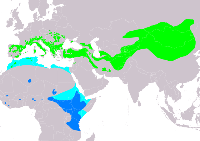
Slovenčina: Mapa rozšírenia druhu skaliar pestrý Monticola saxatilis podľa IUCN verzia 2019.1 :
legenda: Hniezdiaci, výskyt v letnom období (#00FF00), Migrujúci (#00FFFF), Nehniezdiaci (#007FFF) English: The distribution map of common rock thrush Monticola saxatilis according to IUCN version 2019.1 ; key: Legend: Extant, breeding (#00FF00), Extant, passage (#00FFFF), Extant, non-breeding (#007FFF) |
| Dyddiad | |
| Ffynhonnell | Made with Natural Earth. Free vetor and raster map data @ naturalearthdata.com. Range map from BirdLife International 2017. Monticola saxatilis (amended version of 2016 assessment). The IUCN Red List of Threatened Species 2017: e.T22708257A111788908. https://dx.doi.org/10.2305/IUCN.UK.2017-1.RLTS.T22708257A111788908.en. Downloaded on 20 May 2019 as visual indicator of distribution. |
| Awdur | SanoAK: Alexander Kürthy |
Trwyddedu

Trwyddedir y ffeil hon yn ôl termau'r drwydded Creative Commons Attribution-Share Alike 3.0 Unported.
Cydnabyddiaeth: IUCN Red List of Threatened Species, species assessors and the authors of the spatial data.
- Mae'n rhydd i chi:
- rhannu – gallwch gopïo, dosbarthu a throsglwyddo'r gwaith
- ailwampio – gallwch addasu'r gwaith
- Ar yr amodau canlynol:
- cydnabyddiaeth – Mae'n rhaid i chi nodi manylion y gwaith hwn, rhoi dolen i'r drwydded, a nodi os y bu golygu arni, yn y modd a benwyd gan yr awdur neu'r trwyddedwr (ond heb awgrymu o gwbl eu bod yn eich cymeradwyo chi na'ch defnydd o'r gwaith).
- rhannu ar dermau tebyg – Os byddwch yn addasu'r gwaith hwn, neu yn ei drawsnewid, neu yn adeiladu arno, mae'n rhaid i chi ddosbarthu'r gwaith dan drwydded sy'n union yr un fath same a'r gwreiddiol.
Hanes y ffeil
Cliciwch ar ddyddiad / amser i weld y ffeil fel ag yr oedd bryd hynny.
| Dyddiad / Amser | Bawdlun | Hyd a lled | Defnyddiwr | Sylw | |
|---|---|---|---|---|---|
| cyfredol | 09:08, 20 Mai 2019 | | 3,507 × 2,480 (940 KB) | SanoAK | User created page with UploadWizard |
Cysylltiadau'r ffeil
Mae'r 1 tudalennau a ddefnyddir isod yn cysylltu i'r ddelwedd hon:
Defnydd cydwici y ffeil
Mae'r wicis eraill hyn yn defnyddio'r ffeil hon:
- Y defnydd ar an.wikipedia.org
- Y defnydd ar ar.wikipedia.org
- Y defnydd ar arz.wikipedia.org
- Y defnydd ar ast.wikipedia.org
- Y defnydd ar bg.wikipedia.org
- Y defnydd ar ca.wikipedia.org
- Y defnydd ar ceb.wikipedia.org
- Y defnydd ar cs.wikipedia.org
- Y defnydd ar de.wikipedia.org
- Y defnydd ar en.wikipedia.org
- Y defnydd ar eo.wikipedia.org
- Y defnydd ar es.wikipedia.org
- Y defnydd ar eu.wikipedia.org
- Y defnydd ar fr.wikipedia.org
- Y defnydd ar ga.wikipedia.org
- Y defnydd ar he.wikipedia.org
- Y defnydd ar hu.wikipedia.org
- Y defnydd ar hy.wikipedia.org
- Y defnydd ar id.wikipedia.org
- Y defnydd ar nl.wikipedia.org
- Y defnydd ar pl.wikipedia.org
- Y defnydd ar pt.wikipedia.org
- Y defnydd ar ru.wikipedia.org
- Y defnydd ar sk.wikipedia.org
- Y defnydd ar sv.wikipedia.org
- Y defnydd ar uk.wikipedia.org
- Y defnydd ar www.wikidata.org
- Y defnydd ar zh.wikipedia.org