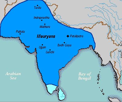
Delwedd:Mauryan Empire Map.gif
Mauryan_Empire_Map.gif ((400 × 337 picsel, maint y ffeil: 11 KB, ffurf MIME: image/gif))
Hanes y ffeil
Cliciwch ar ddyddiad / amser i weld y ffeil fel ag yr oedd bryd hynny.
| Dyddiad / Amser | Bawdlun | Hyd a lled | Defnyddiwr | Sylw | |
|---|---|---|---|---|---|
| cyfredol | 00:16, 25 Mawrth 2016 |  | 400 × 337 (11 KB) | LouisAragon | rv, changes made by a banned user. |
| 01:14, 23 Ebrill 2007 |  | 400 × 337 (11 KB) | Jagged 85 | ||
| 23:02, 13 Rhagfyr 2006 |  | 400 × 337 (11 KB) | Electionworld | {{ew|en|Vastu}} {{ShouldBeSVG}} ==Description== A poltical map of the Mauryan Empire, including notable cities, such as the capital Pataliputra, and site of the Buddha's enlightenment. ===Key=== Dark blue represents the extend of the Maur |
Cysylltiadau'r ffeil
Mae'r 1 tudalennau a ddefnyddir isod yn cysylltu i'r ddelwedd hon:
Defnydd cydwici y ffeil
Mae'r wicis eraill hyn yn defnyddio'r ffeil hon:
- Y defnydd ar anp.wikipedia.org
- Y defnydd ar bh.wikipedia.org
- Y defnydd ar bn.wikipedia.org
- Y defnydd ar bpy.wikipedia.org
- Y defnydd ar ca.wikipedia.org
- Y defnydd ar cs.wikipedia.org
- Y defnydd ar da.wikipedia.org
- Y defnydd ar en.wikipedia.org
- Y defnydd ar eo.wikipedia.org
- Y defnydd ar fa.wikipedia.org
- Y defnydd ar fi.wikipedia.org
- Y defnydd ar fi.wikibooks.org
- Y defnydd ar fr.wikipedia.org
- Y defnydd ar gu.wikipedia.org
- Y defnydd ar he.wikipedia.org
- Y defnydd ar hi.wikipedia.org
- Y defnydd ar it.wikipedia.org
- Y defnydd ar ka.wikipedia.org
- Y defnydd ar ko.wikipedia.org
- Y defnydd ar la.wikipedia.org
- Y defnydd ar lt.wikipedia.org
- Y defnydd ar lv.wikipedia.org
- Y defnydd ar ml.wikipedia.org
- Y defnydd ar mr.wikipedia.org
- Y defnydd ar ne.wikipedia.org
- Y defnydd ar nl.wikipedia.org
Gweld rhagor o'r defnydd cydwici o'r ffeil hon.


