
Delwedd:Maricopa County Incorporated and Planning areas Avondale highlighted.svg

Maint rhagolwg PNG o ffeil SVG yw: 694 × 599 picsel. Eglurdebau eraill: 278 × 240 picsel | 556 × 480 picsel | 889 × 768 picsel | 1,185 × 1,024 picsel | 2,371 × 2,048 picsel | 940 × 812 picsel.
Maint llawn (Ffeil SVG, maint mewn enw 940 × 812 picsel, maint y ffeil: 1.05 MB)
Crynodeb
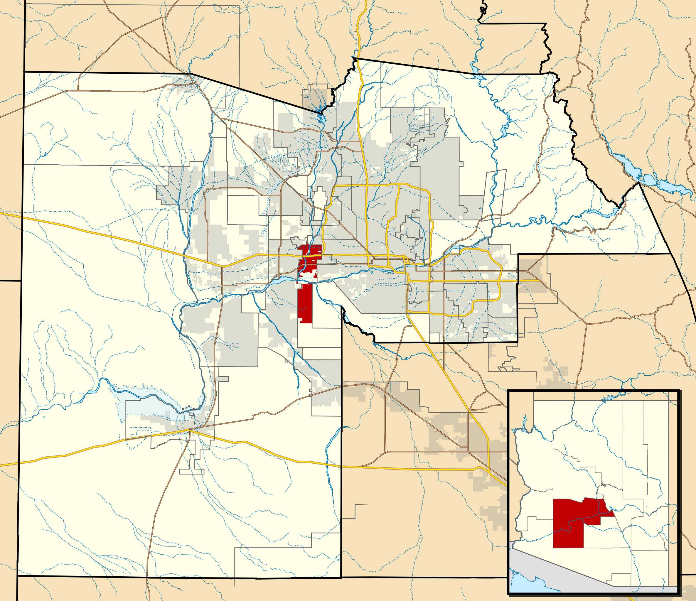
| Disgrifiad | This map shows the incorporated areas and Indian reservation boundaries in Maricopa County, Arizona, along with water bodies and major highways and roads. Avondale is highlighted in red. Other incorporated cities are shown in gray, planning area borders for these cities and Indian reservation borders are shown as solid black lines. Changes from Previous Version: Updated the maps to include water bodies and to make "less boring" than the plain black/white/gray maps. Format was updated to match standards laid out by WikiProject Maps/Conventions. Map data is based on data from the following Webpage: Maricopa County Interactive GIS Map. I created this map in Inkscape. |
| Dyddiad | |
| Ffynhonnell | My own work, based on government information |
| Awdur | Ixnayonthetimmay |
| Caniatâd (Ailddefnyddio'r ffeil hon) |
Public Domain |
| Diwygiadau eraill | See Category:Maps of Maricopa County for other versions of this image. |
Trwyddedu
| Yr wyf fi, deiliad hawlfraint y gwaith hwn, yn ei ryddhau i'r parth cyhoeddus, a hynny'n fyd-eang. Hwyrach nad yw hyn yn bosib yn ôl cyfraith rhai gwledydd; os felly: Rwyn rhoi i unrhywun yr hawl i ddefnyddio'r gwaith hwn at unrhyw ddiben, heb unrhyw amodau, oddieithr unrhyw amodau gofynnol yn ôl y gyfraith. |
Hanes y ffeil
Cliciwch ar ddyddiad / amser i weld y ffeil fel ag yr oedd bryd hynny.
| Dyddiad / Amser | Bawdlun | Hyd a lled | Defnyddiwr | Sylw | |
|---|---|---|---|---|---|
| cyfredol | 06:08, 20 Mai 2011 | | 940 × 812 (1.05 MB) | Ixnayonthetimmay | Uploading new version |
| 03:55, 30 Awst 2008 |  | 900 × 800 (413 KB) | Ixnayonthetimmay | == Summary == {{Information |Description=This map shows the incorporated areas and unincorporated areas in Maricopa County, Arizona. [[:en:Avondale, Arizona| | |
| 00:14, 16 Medi 2007 |  | 900 × 800 (384 KB) | Ixnayonthetimmay | {{Information |Description= |Source= |Date= |Author= |Permission= |other_versions= }} | |
| 09:49, 28 Mai 2007 |  | 900 × 780 (329 KB) | Ixnayonthetimmay | ||
| 23:47, 21 Mai 2007 |  | 900 × 780 (318 KB) | Ixnayonthetimmay | ||
| 04:02, 30 Ionawr 2007 |  | 904 × 758 (177 KB) | Ixnayonthetimmay | {{Information |Description=This map shows the incorporated areas in Maricopa County, Arizona, highlighting Avondale in red. It also shows the boundaries for the | |
| 04:00, 30 Ionawr 2007 |  | 904 × 758 (177 KB) | Ixnayonthetimmay | {{Information |Description=This map shows the incorporated areas in Maricopa County, Arizona, highlighting Avondale in red. It also shows the boundaries for the |
Cysylltiadau'r ffeil
Mae'r 1 tudalennau a ddefnyddir isod yn cysylltu i'r ddelwedd hon:
Defnydd cydwici y ffeil
Mae'r wicis eraill hyn yn defnyddio'r ffeil hon:
- Y defnydd ar ar.wikipedia.org
- Y defnydd ar arz.wikipedia.org
- Y defnydd ar ca.wikipedia.org
- Y defnydd ar ceb.wikipedia.org
- Y defnydd ar de.wikipedia.org
- Y defnydd ar eu.wikipedia.org
- Y defnydd ar fa.wikipedia.org
- Y defnydd ar fr.wikipedia.org
- Y defnydd ar ht.wikipedia.org
- Y defnydd ar io.wikipedia.org
- Y defnydd ar no.wikipedia.org
- Y defnydd ar pt.wikipedia.org
- Y defnydd ar ro.wikipedia.org
- Y defnydd ar sr.wikipedia.org
- Y defnydd ar sv.wikipedia.org
- Y defnydd ar sw.wikipedia.org
- Y defnydd ar tr.wikipedia.org
- Y defnydd ar tt.wikipedia.org
- Y defnydd ar ur.wikipedia.org
- Y defnydd ar vo.wikipedia.org
- Y defnydd ar www.wikidata.org
- Y defnydd ar zh-min-nan.wikipedia.org