
Delwedd:Mali.A2001291.1045.250m.jpg

Maint y rhagolwg: 800 × 600 picsel. Eglurdebau eraill: 320 × 240 picsel | 640 × 480 picsel | 1,024 × 768 picsel | 1,280 × 960 picsel | 2,560 × 1,920 picsel | 4,000 × 3,000 picsel.
Maint llawn ((4,000 × 3,000 picsel, maint y ffeil: 1.75 MB, ffurf MIME: image/jpeg))
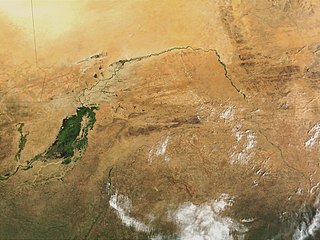
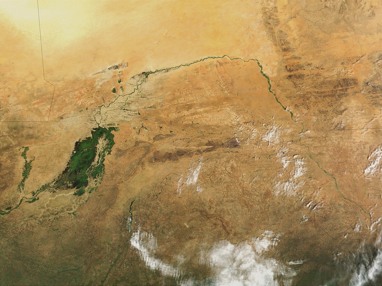
| Disgrifiad | Niger River in Mali, 2001. Just south of the Sahara Desert in Africa, the Niger River creates a lush area of wetlands and lakes in an otherwise arid environment. In this true-color MODIS image from October 18, 2001, the Niger enters at left as a thin strip of green and flows northeast through Mali. The river then turns south and heads into the country of Niger. (Note, this is at the end of the rainy season, showing the Niger Inland Delta in dark green). | |||||
| Dyddiad |
Visualization Date 2001-10-18 |
|||||
| Ffynhonnell | http://veimages.gsfc.nasa.gov/2243/Mali.A2001291.1045.250m.jpg | |||||
| Awdur | Jacques Descloitres, MODIS Land Rapid Response Team, NASA/GSFC | |||||
| Caniatâd (Ailddefnyddio'r ffeil hon) |
PD, US Gov
|

Hanes y ffeil
Cliciwch ar ddyddiad / amser i weld y ffeil fel ag yr oedd bryd hynny.
| Dyddiad / Amser | Bawdlun | Hyd a lled | Defnyddiwr | Sylw | |
|---|---|---|---|---|---|
| cyfredol | 22:43, 8 Mawrth 2008 | | 4,000 × 3,000 (1.75 MB) | T L Miles | {{Information |Description=Niger River in Mali, 2001. Just south of the Sahara Desert in Africa, the Niger River creates a lush area of wetlands and lakes in an otherwise arid environment. In this true-color MODIS image from October 18, 2001, the Niger en |
Cysylltiadau'r ffeil
Mae'r 1 tudalennau a ddefnyddir isod yn cysylltu i'r ddelwedd hon:
Defnydd cydwici y ffeil
Mae'r wicis eraill hyn yn defnyddio'r ffeil hon:
- Y defnydd ar af.wikipedia.org
- Y defnydd ar as.wikipedia.org
- Y defnydd ar bg.wikipedia.org
- Y defnydd ar ca.wikipedia.org
- Y defnydd ar en.wikipedia.org
- Y defnydd ar eo.wikipedia.org
- Y defnydd ar fr.wikipedia.org
- Y defnydd ar ilo.wikipedia.org
- Y defnydd ar ja.wikipedia.org
- Y defnydd ar la.wikipedia.org
- Y defnydd ar no.wikipedia.org
- Y defnydd ar oc.wikipedia.org
- Y defnydd ar pt.wikipedia.org
- Y defnydd ar sr.wikipedia.org
- Y defnydd ar sv.wikipedia.org
- Y defnydd ar sw.wikipedia.org
- Y defnydd ar ta.wikipedia.org
- Y defnydd ar uk.wikipedia.org
- Y defnydd ar zh.wikipedia.org