
Delwedd:EnglandWarwickshire.svg

Maint rhagolwg PNG o ffeil SVG yw: 200 × 247 picsel. Eglurdebau eraill: 194 × 240 picsel | 389 × 480 picsel | 622 × 768 picsel | 829 × 1,024 picsel | 1,658 × 2,048 picsel.
Maint llawn (Ffeil SVG, maint mewn enw 200 × 247 picsel, maint y ffeil: 231 KB)
Crynodeb
| Disgrifiad |
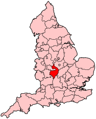
English: Map of Warwickshire within England. |
| Ffynhonnell | Gwaith yr uwchlwythwr |
| Awdur | Wereon |
Trwyddedu
| Yr wyf fi, deiliad hawlfraint y gwaith hwn, yn ei ryddhau i'r parth cyhoeddus, a hynny'n fyd-eang. Hwyrach nad yw hyn yn bosib yn ôl cyfraith rhai gwledydd; os felly: Rwyn rhoi i unrhywun yr hawl i ddefnyddio'r gwaith hwn at unrhyw ddiben, heb unrhyw amodau, oddieithr unrhyw amodau gofynnol yn ôl y gyfraith. |
Hanes y ffeil
Cliciwch ar ddyddiad / amser i weld y ffeil fel ag yr oedd bryd hynny.
| Dyddiad / Amser | Bawdlun | Hyd a lled | Defnyddiwr | Sylw | |
|---|---|---|---|---|---|
| cyfredol | 20:49, 22 Ebrill 2007 | | 200 × 247 (231 KB) | Wereon | Map of Warwickshire within England. Category:Maps of counties of England |
Cysylltiadau'r ffeil
Mae'r 6 tudalennau a ddefnyddir isod yn cysylltu i'r ddelwedd hon:
Defnydd cydwici y ffeil
Mae'r wicis eraill hyn yn defnyddio'r ffeil hon:
- Y defnydd ar en.wikipedia.org
- Warwick and Leamington (UK Parliament constituency)
- Rugby and Kenilworth (UK Parliament constituency)
- Nuneaton (UK Parliament constituency)
- North Warwickshire (UK Parliament constituency)
- Stratford-on-Avon (UK Parliament constituency)
- Kenilworth and Southam (UK Parliament constituency)
- Rugby (UK Parliament constituency)
- Parliamentary constituencies in the West Midlands (region)
- Y defnydd ar fr.wikipedia.org
- Kenilworth and Southam (circonscription britannique)
- North Warwickshire (circonscription britannique)
- Nuneaton (circonscription britannique)
- Rugby (circonscription britannique)
- Stratford-on-Avon (circonscription britannique)
- Warwick and Leamington (circonscription du Parlement britannique)
- Liste des circonscriptions parlementaires des West Midlands
- Y defnydd ar pl.wikipedia.org