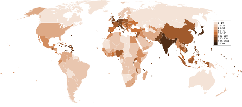
Delwedd:Countries by population density.svg

Maint rhagolwg PNG o ffeil SVG yw: 800 × 353 picsel. Eglurdebau eraill: 320 × 141 picsel | 640 × 282 picsel | 1,024 × 452 picsel | 1,280 × 565 picsel | 2,560 × 1,129 picsel | 6,000 × 2,647 picsel.
Maint llawn (Ffeil SVG, maint mewn enw 6,000 × 2,647 picsel, maint y ffeil: 1.62 MB)
Hanes y ffeil
Cliciwch ar ddyddiad / amser i weld y ffeil fel ag yr oedd bryd hynny.
| Dyddiad / Amser | Bawdlun | Hyd a lled | Defnyddiwr | Sylw | |
|---|---|---|---|---|---|
| cyfredol | 23:33, 21 Rhagfyr 2011 |  | 6,000 × 2,647 (1.62 MB) | Quibik | added transparency |
| 13:43, 20 Chwefror 2011 |  | 6,000 × 2,647 (1.62 MB) | Erik del Toro Streb | typographically corrected | |
| 02:22, 7 Ionawr 2008 |  | 6,000 × 2,647 (1.62 MB) | Briefplan~commonswiki | {{Information |Description=A map of the world, with colours to highlight the population density of each country or territory. Numbers on the legend are in people per km<sup>2</sup>, and all countries smaller than 20,000 km<sup>2</sup> are represented by a |
Cysylltiadau'r ffeil
Mae'r 1 tudalennau a ddefnyddir isod yn cysylltu i'r ddelwedd hon:
Defnydd cydwici y ffeil
Mae'r wicis eraill hyn yn defnyddio'r ffeil hon:
- Y defnydd ar af.wikipedia.org
- Y defnydd ar ar.wikipedia.org
- Y defnydd ar arz.wikipedia.org
- Y defnydd ar ast.wikipedia.org
- Y defnydd ar av.wikipedia.org
- Y defnydd ar awa.wikipedia.org
- Y defnydd ar azb.wikipedia.org
- Y defnydd ar az.wikipedia.org
- Y defnydd ar ba.wikipedia.org
- Y defnydd ar be.wikipedia.org
- Y defnydd ar bg.wikipedia.org
- Y defnydd ar bs.wikipedia.org
- Y defnydd ar ca.wikipedia.org
- Y defnydd ar ckb.wikipedia.org
- Y defnydd ar cs.wikipedia.org
- Y defnydd ar de.wikipedia.org
- Y defnydd ar de.wikiversity.org
- Y defnydd ar diq.wikipedia.org
- Y defnydd ar dsb.wikipedia.org
- Y defnydd ar en.wikipedia.org
- Y defnydd ar eo.wikipedia.org
- Y defnydd ar es.wikipedia.org
- Y defnydd ar eu.wikipedia.org
- Y defnydd ar fi.wikipedia.org
- Y defnydd ar fr.wikipedia.org
- Y defnydd ar gl.wikipedia.org
Gweld rhagor o'r defnydd cydwici o'r ffeil hon.
