
Delwedd:Calcareous Soil Profile, Seven Sisters Country Park - geograph.org.uk - 1280181.jpg
Wedi ei chwyddo hyd yr eithaf.
Calcareous_Soil_Profile,_Seven_Sisters_Country_Park_-_geograph.org.uk_-_1280181.jpg ((640 × 430 picsel, maint y ffeil: 70 KB, ffurf MIME: image/jpeg))
Crynodeb
| Disgrifiad |
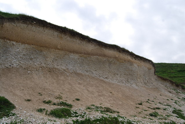
English: Calcareous Soil Profile, Seven Sisters Country Park A well defined soil profile on chalk.
The dark organic ricn humus layer can clearly be seen at the top of the profile. below it is a bleached horizon where nutrients have been leached out & below this is a darker reddish layer of redeposition. At the base of the profile is the weathered bedrock (chalk)the unweathered chalk is hidden. This soil profile is a Rendzina Rendzina |
| Dyddiad | |
| Ffynhonnell | From geograph.org.uk |
| Awdur | Nigel Chadwick |
| Camera location | | View this and other nearby images on: OpenStreetMap |
|---|
_heading:135.00&language=cy)
| Object location | | View this and other nearby images on: OpenStreetMap |
|---|
_heading:135.00&language=cy)
Trwyddedu

|
This image was taken from the Geograph project collection. See this photograph's page on the Geograph website for the photographer's contact details. The copyright on this image is owned by Nigel Chadwick and is licensed for reuse under the Creative Commons Attribution-ShareAlike 2.0 license.
|
Trwyddedir y ffeil hon yn ôl termau'r drwydded Creative Commons Attribution-Share Alike 2.0 Generic.
Cydnabyddiaeth: Nigel Chadwick
- Mae'n rhydd i chi:
- rhannu – gallwch gopïo, dosbarthu a throsglwyddo'r gwaith
- ailwampio – gallwch addasu'r gwaith
- Ar yr amodau canlynol:
- cydnabyddiaeth – Mae'n rhaid i chi nodi manylion y gwaith hwn, rhoi dolen i'r drwydded, a nodi os y bu golygu arni, yn y modd a benwyd gan yr awdur neu'r trwyddedwr (ond heb awgrymu o gwbl eu bod yn eich cymeradwyo chi na'ch defnydd o'r gwaith).
- rhannu ar dermau tebyg – Os byddwch yn addasu'r gwaith hwn, neu yn ei drawsnewid, neu yn adeiladu arno, mae'n rhaid i chi ddosbarthu'r gwaith dan drwydded sy'n union yr un fath same a'r gwreiddiol.
Hanes y ffeil
Cliciwch ar ddyddiad / amser i weld y ffeil fel ag yr oedd bryd hynny.
| Dyddiad / Amser | Bawdlun | Hyd a lled | Defnyddiwr | Sylw | |
|---|---|---|---|---|---|
| cyfredol | 05:41, 27 Chwefror 2011 | | 640 × 430 (70 KB) | GeographBot | == {{int:filedesc}} == {{Information |description={{en|1=Calcareous Soil Profile, Seven Sisters Country Park A well defined soil profile on chalk. The dark organic ricn humus layer can clearly be seen at the top of the profile. below it is a bleached hor |
Cysylltiadau'r ffeil
Mae'r 1 tudalennau a ddefnyddir isod yn cysylltu i'r ddelwedd hon:
Defnydd cydwici y ffeil
Mae'r wicis eraill hyn yn defnyddio'r ffeil hon:
- Y defnydd ar ar.wikipedia.org
- Y defnydd ar bn.wikipedia.org
- Y defnydd ar de.wikipedia.org
- Y defnydd ar en.wikipedia.org
- Y defnydd ar es.wikipedia.org
- Y defnydd ar fa.wikipedia.org
- Y defnydd ar fi.wikipedia.org
- Y defnydd ar ha.wikipedia.org
- Y defnydd ar la.wikipedia.org
- Y defnydd ar mk.wikipedia.org
- Y defnydd ar pa.wikipedia.org
- Y defnydd ar si.wikipedia.org
- Y defnydd ar zh-yue.wikipedia.org