
Delwedd:Cabinda pol77.jpg

Maint y rhagolwg: 455 × 599 picsel. Eglurdebau eraill: 182 × 240 picsel | 364 × 480 picsel | 583 × 768 picsel | 1,040 × 1,370 picsel.
Maint llawn ((1,040 × 1,370 picsel, maint y ffeil: 160 KB, ffurf MIME: image/jpeg))

|
File:Cabinda map-fr.svg is a vector version of this file. It should be used in place of this JPG file when not inferior.
File:Cabinda pol77.jpg → File:Cabinda map-fr.svg
For more information, see Help:SVG. |
 |
Crynodeb
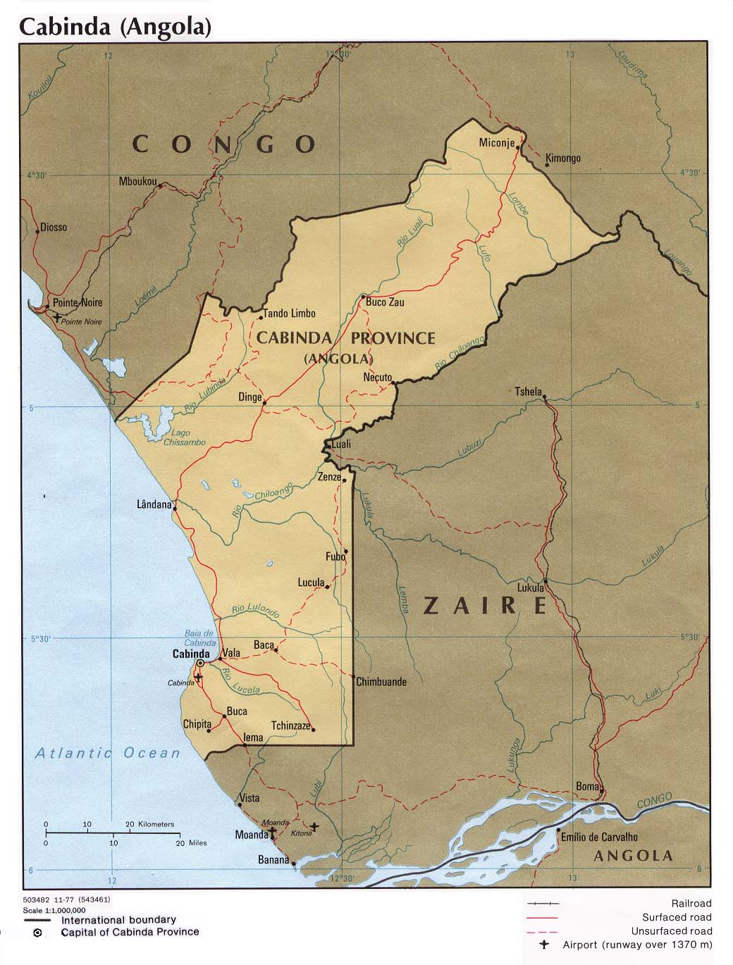
| Disgrifiad | Political map of the Cabinda province, Angola. |
| Dyddiad | |
| Ffynhonnell | University of Texas Libraries, Perry-Castañeda Library Map Collection: Angola Maps |
| Awdur | CIA |
| Diwygiadau eraill | Derivative works of this file: Cabinda map-fr.svg |
Trwyddedu
| This image is a work of a Central Intelligence Agency employee, taken or made as part of that person's official duties. As a Work of the United States Government, this image or media is in the public domain in the United States.
|

|
derivative works
Hanes y ffeil
Cliciwch ar ddyddiad / amser i weld y ffeil fel ag yr oedd bryd hynny.
| Dyddiad / Amser | Bawdlun | Hyd a lled | Defnyddiwr | Sylw | |
|---|---|---|---|---|---|
| cyfredol | 18:34, 23 Ebrill 2007 | | 1,040 × 1,370 (160 KB) | Kipala | http://www.lib.utexas.edu/maps/africa/cabinda_pol77.jpg From the Perry Castaneda Map Collection "Courtesy of the University of Texas Libraries, The University of Texas at Austin." |
Cysylltiadau'r ffeil
Mae'r 2 tudalennau a ddefnyddir isod yn cysylltu i'r ddelwedd hon:
Defnydd cydwici y ffeil
Mae'r wicis eraill hyn yn defnyddio'r ffeil hon:
- Y defnydd ar ar.wikipedia.org
- Y defnydd ar azb.wikipedia.org
- Y defnydd ar br.wikipedia.org
- Y defnydd ar ca.wikipedia.org
- Y defnydd ar co.wikipedia.org
- Y defnydd ar da.wikipedia.org
- Y defnydd ar de.wikipedia.org
- Y defnydd ar el.wikipedia.org
- Y defnydd ar en.wikipedia.org
- Y defnydd ar eo.wikipedia.org
- Y defnydd ar eo.wikivoyage.org
- Y defnydd ar es.wikipedia.org
- Y defnydd ar eu.wikipedia.org
- Y defnydd ar fa.wikipedia.org
- Y defnydd ar fi.wikipedia.org
- Y defnydd ar fo.wikipedia.org
- Y defnydd ar fr.wikipedia.org
- Y defnydd ar ha.wikipedia.org
- Y defnydd ar he.wikipedia.org
- Y defnydd ar hu.wikipedia.org
- Y defnydd ar it.wikipedia.org
- Y defnydd ar ka.wikipedia.org
- Y defnydd ar kg.wikipedia.org
- Y defnydd ar ko.wikipedia.org
- Y defnydd ar la.wikipedia.org
- Y defnydd ar ln.wikipedia.org
- Y defnydd ar lt.wikipedia.org
- Y defnydd ar mk.wikipedia.org
- Y defnydd ar nl.wikipedia.org
- Y defnydd ar nn.wikipedia.org
- Y defnydd ar no.wikipedia.org
Gweld rhagor o'r defnydd cydwici o'r ffeil hon.