
Delwedd:Bolingey - geograph.org.uk - 66038.jpg
Wedi ei chwyddo hyd yr eithaf.
Bolingey_-_geograph.org.uk_-_66038.jpg ((640 × 467 picsel, maint y ffeil: 101 KB, ffurf MIME: image/jpeg))
Crynodeb
| Disgrifiad |
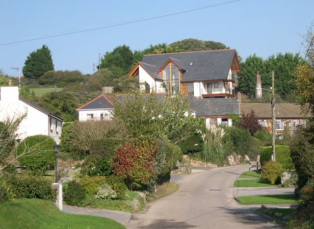
English: Bolingey. Bolingey is a very pleasant looking village about a mile to the south of Perranporth. The view from the western road into the village is dominated by an extraordinary looking building which towers above the level of the other houses. Although an attempt has been made to make it blend in with the houses below, the effect is like painting stripes on an elephant to make it blend in with the zebras. |
| Dyddiad | |
| Ffynhonnell | From geograph.org.uk |
| Awdur | Tony Atkin |
| Cydnabyddiaeth (required by the license) | Tony Atkin / Bolingey / |
| Camera location | | View this and other nearby images on: OpenStreetMap |
|---|
_&language=cy)
| Object location | | View this and other nearby images on: OpenStreetMap |
|---|
_&language=cy)
Trwyddedu

|
This image was taken from the Geograph project collection. See this photograph's page on the Geograph website for the photographer's contact details. The copyright on this image is owned by Tony Atkin and is licensed for reuse under the Creative Commons Attribution-ShareAlike 2.0 license.
|
Trwyddedir y ffeil hon yn ôl termau'r drwydded Creative Commons Attribution-Share Alike 2.0 Generic.
Cydnabyddiaeth: Tony Atkin
- Mae'n rhydd i chi:
- rhannu – gallwch gopïo, dosbarthu a throsglwyddo'r gwaith
- ailwampio – gallwch addasu'r gwaith
- Ar yr amodau canlynol:
- cydnabyddiaeth – Mae'n rhaid i chi nodi manylion y gwaith hwn, rhoi dolen i'r drwydded, a nodi os y bu golygu arni, yn y modd a benwyd gan yr awdur neu'r trwyddedwr (ond heb awgrymu o gwbl eu bod yn eich cymeradwyo chi na'ch defnydd o'r gwaith).
- rhannu ar dermau tebyg – Os byddwch yn addasu'r gwaith hwn, neu yn ei drawsnewid, neu yn adeiladu arno, mae'n rhaid i chi ddosbarthu'r gwaith dan drwydded sy'n union yr un fath same a'r gwreiddiol.
Hanes y ffeil
Cliciwch ar ddyddiad / amser i weld y ffeil fel ag yr oedd bryd hynny.
| Dyddiad / Amser | Bawdlun | Hyd a lled | Defnyddiwr | Sylw | |
|---|---|---|---|---|---|
| cyfredol | 13:25, 30 Ionawr 2010 | | 640 × 467 (101 KB) | GeographBot | == {{int:filedesc}} == {{Information |description={{en|1=Bolingey. Bolingey is a very pleasant looking village about a mile to the south of Perranporth. The view from the western road into the village is dominated by an extraordinary looking building whi |
Cysylltiadau'r ffeil
Mae'r 1 tudalennau a ddefnyddir isod yn cysylltu i'r ddelwedd hon:
Defnydd cydwici y ffeil
Mae'r wicis eraill hyn yn defnyddio'r ffeil hon:
- Y defnydd ar ar.wikipedia.org
- Y defnydd ar arz.wikipedia.org
- Y defnydd ar en.wikipedia.org
- Y defnydd ar eu.wikipedia.org
- Y defnydd ar fr.wikipedia.org
- Y defnydd ar kw.wikipedia.org
- Y defnydd ar pl.wikipedia.org
- Y defnydd ar simple.wikipedia.org
- Y defnydd ar tr.wikipedia.org
- Y defnydd ar www.wikidata.org