
Delwedd:Betws Bledrws - geograph.org.uk - 755570.jpg
Wedi ei chwyddo hyd yr eithaf.
Betws_Bledrws_-_geograph.org.uk_-_755570.jpg ((640 × 480 picsel, maint y ffeil: 75 KB, ffurf MIME: image/jpeg))
Crynodeb
| Disgrifiad |
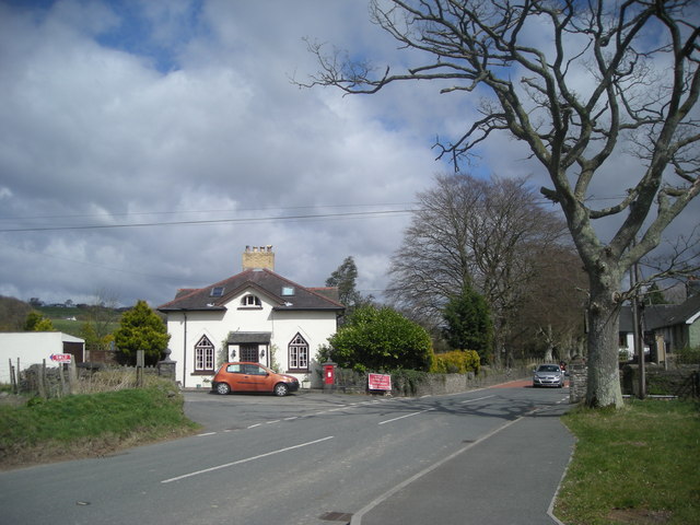
English: Betws Bledrws The small village of Betws Bledrws lies three miles from Lampeter on either side of the A485. It comprises two parts: Bro Deri, a row of council houses in the north of square SN5951 and the village proper shown here.
The white building is New Lodge, built in c.1840 to the design of Charles Cockerell, who also designed the house whose gate it guarded, Derry Ormond Park (demolished in 1953). Cockerell was also responsible for the designs of St. David's College (now the University of Wales, Lampeter) and Derry Ormond Tower. |
| Dyddiad | |
| Ffynhonnell | From geograph.org.uk |
| Awdur | Dan Gregory |
| Cydnabyddiaeth (required by the license) | Dan Gregory / Betws Bledrws / |
| Camera location | | View this and other nearby images on: OpenStreetMap |
|---|
_heading:45.00&language=cy)
| Object location | | View this and other nearby images on: OpenStreetMap |
|---|
_heading:45.00&language=cy)
Trwyddedu

|
This image was taken from the Geograph project collection. See this photograph's page on the Geograph website for the photographer's contact details. The copyright on this image is owned by Dan Gregory and is licensed for reuse under the Creative Commons Attribution-ShareAlike 2.0 license.
|
Trwyddedir y ffeil hon yn ôl termau'r drwydded Creative Commons Attribution-Share Alike 2.0 Generic.
Cydnabyddiaeth: Dan Gregory
- Mae'n rhydd i chi:
- rhannu – gallwch gopïo, dosbarthu a throsglwyddo'r gwaith
- ailwampio – gallwch addasu'r gwaith
- Ar yr amodau canlynol:
- cydnabyddiaeth – Mae'n rhaid i chi nodi manylion y gwaith hwn, rhoi dolen i'r drwydded, a nodi os y bu golygu arni, yn y modd a benwyd gan yr awdur neu'r trwyddedwr (ond heb awgrymu o gwbl eu bod yn eich cymeradwyo chi na'ch defnydd o'r gwaith).
- rhannu ar dermau tebyg – Os byddwch yn addasu'r gwaith hwn, neu yn ei drawsnewid, neu yn adeiladu arno, mae'n rhaid i chi ddosbarthu'r gwaith dan drwydded sy'n union yr un fath same a'r gwreiddiol.
Hanes y ffeil
Cliciwch ar ddyddiad / amser i weld y ffeil fel ag yr oedd bryd hynny.
| Dyddiad / Amser | Bawdlun | Hyd a lled | Defnyddiwr | Sylw | |
|---|---|---|---|---|---|
| cyfredol | 14:18, 19 Chwefror 2011 | | 640 × 480 (75 KB) | GeographBot | == {{int:filedesc}} == {{Information |description={{en|1=Betws Bledrws The small village of Betws Bledrws lies three miles from Lampeter on either side of the A485. It comprises two parts: Bro Deri, a row of council houses in the north of square [[SN5951] |
Cysylltiadau'r ffeil
Mae'r 1 tudalennau a ddefnyddir isod yn cysylltu i'r ddelwedd hon:
Defnydd cydwici y ffeil
Mae'r wicis eraill hyn yn defnyddio'r ffeil hon:
- Y defnydd ar en.wikipedia.org
- Y defnydd ar www.wikidata.org