
Delwedd:Arabic Varieties Map.svg

Maint llawn (Ffeil SVG, maint mewn enw 2,051 × 1,151 picsel, maint y ffeil: 2.08 MB)

|
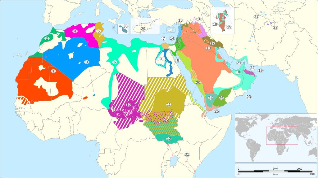
This file has been superseded by Arabic Varieties Map-2023.svg. It is recommended to use the other file. Please note that deleting superseded images requires consent.
|

|

| Annotations | This image is annotated: View the annotations at Commons |
Crynodeb
| Disgrifiad |
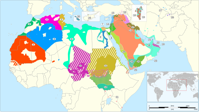
English: Map of the geographical distribution of the various varieties of Arabic recognized as languages by the ISO 639-3 standard, including Arabic-based creoles but excluding Judeo-Arabic languages.
1: Hassaniyya (mey) 2: Arabeg Moroco (الدارجة) 3: Algerian Saharan Arabic (aao) 4: Arabeg Algeria (جازايرية) 5: Arabeg Tunisia (تونسي / Tûnsî) 6: Libyan Arabic (ayl) 7: Arabeg yr Aifft (مصرى) 8: Eastern Egyptian Bedawi Arabic (avl) 9: Saidi Arabic (aec) 10: Arabeg Chad (shu) 11: Sudanese Arabic (apd) 12: Sudanese Creole Arabic (pga) 13: Arabeg Najdi (ars) 14: South Levantine Arabic (ajp) 15: North Levantine Arabic (apc) 16: North Mesopotamian Arabic (ayp) 17: Mesopotamian Arabic (عراقي) 18: Gulf Arabic (afb) 19: Baharna Arabic (abv) 20: Hijazi Arabic (acw) 21: Shihhi Arabic (ssh) 22: Omani Arabic (acx) 23: Dhofari Arabic (adf) 24: Sanaani Arabic (ayn) 25: Ta'izzi-Adeni Arabic (acq) 26: Hadrami Arabic (ayh) 27: Uzbeki Arabic (auz) 28: Tajiki Arabic (abh) 29: Cypriot Arabic (acy) 30: Malteg (Malti) 31: Nubi (kcn) Sparsely populated area or no indigenous Arabic speakers Solid area fill: variety natively spoken by at least 25% of the population of that area or variety indigenous to that area only Hatched area fill: minority scattered over the area Dotted area fill: speakers of this variety are mixed with speakers of other Arabic varieties in the area
|
||||||||||
| Dyddiad | |||||||||||
| Ffynhonnell |
Own work based on: Own work using: OSM References:
|
||||||||||
| Awdur | Goran_tek-en | ||||||||||
| Caniatâd (Ailddefnyddio'r ffeil hon) |
Trwyddedir y ffeil hon yn ôl termau'r drwydded Creative Commons Attribution-Share Alike 4.0 International. Cydnabyddiaeth: Goran_tek-en
|
||||||||||
| Diwygiadau eraill |
|
||||||||||
| SVG genesis | This vector image was created with Inkscape. |
||||||||||


| Object location | | View this and other nearby images on: OpenStreetMap |
|---|


.gif)
Hanes y ffeil
Cliciwch ar ddyddiad / amser i weld y ffeil fel ag yr oedd bryd hynny.
| Dyddiad / Amser | Bawdlun | Hyd a lled | Defnyddiwr | Sylw | |
|---|---|---|---|---|---|
| cyfredol | 12:19, 20 Tachwedd 2022 | | 2,051 × 1,151 (2.08 MB) | Goran tek-en | Edited 13/20 pattern as requested by A455bcd9 |
| 11:44, 14 Tachwedd 2022 |  | 2,051 × 1,151 (1.99 MB) | Goran tek-en | Bahrain edited as requested by A455bcd9 | |
| 18:18, 7 Tachwedd 2022 |  | 2,051 × 1,151 (1.96 MB) | Goran tek-en | {{Information |description ={{en|Map of the geographical distribution of the various varieties of Arabic recognized by the ISO 639-3 standard, including Arabic-based creoles but excluding Judeo-Arabic languages.}}<br> {| class="wikitable" |- | width = "30px" bgcolor = "#ff4900" | ||style=text-align:right| 1 || width = "250px" | Hassaniyya (mey) || w... |
Cysylltiadau'r ffeil
Mae'r 2 tudalennau a ddefnyddir isod yn cysylltu i'r ddelwedd hon:
Defnydd cydwici y ffeil
Mae'r wicis eraill hyn yn defnyddio'r ffeil hon:
- Y defnydd ar ab.wikipedia.org
- Y defnydd ar af.wikipedia.org
- Y defnydd ar ar.wikiquote.org
- Y defnydd ar arz.wikipedia.org
- Y defnydd ar ast.wikipedia.org
- Y defnydd ar as.wikipedia.org
- Y defnydd ar av.wikipedia.org
- Y defnydd ar azb.wikipedia.org
- Y defnydd ar az.wikipedia.org
- Y defnydd ar bat-smg.wikipedia.org
- Y defnydd ar ba.wikipedia.org
- Y defnydd ar bg.wikipedia.org
- Y defnydd ar bh.wikipedia.org
- Y defnydd ar br.wikipedia.org
- Y defnydd ar bs.wikipedia.org
- Y defnydd ar ca.wikipedia.org
- Y defnydd ar ceb.wikipedia.org
- Y defnydd ar chy.wikipedia.org
- Y defnydd ar cs.wikipedia.org
- Y defnydd ar de.wikipedia.org
- Y defnydd ar de.wikivoyage.org
- Y defnydd ar el.wikipedia.org
- Y defnydd ar eml.wikipedia.org
- Y defnydd ar en.wikipedia.org
Gweld rhagor o'r defnydd cydwici o'r ffeil hon.