Barry County, Michigan: Gwahaniaeth rhwng fersiynau
Wikidata list updated [V2] |
Misoedd cyfeiriadaeth using AWB |
||
| Llinell 10: | Llinell 10: | ||
<!--Ffinio ac amser--> |
<!--Ffinio ac amser--> |
||
{{if then show| {{#invoke:Wikidata|getRawValue|P47|FETCH_WIKIDATA}}||Mae'n ffinio gyda|.}}<!--CYPLYSU--> {{if then show| {{#invoke:Wikidata|getRawValue|P421|FETCH_WIKIDATA}}||Ceir 9 cylchfa amser yn UDA, ac mae'r sir hon yn perthyn i'r cylchfa amser a elwir yn |.}}<!--CYPLYSU--> {{if then show| {{#invoke:Wikidata|getRawValue|P1456|FETCH_WIKIDATA}}||Cedwir rhestr swyddogol o [[heneb |
{{if then show| {{#invoke:Wikidata|getRawValue|P47|FETCH_WIKIDATA}}||Mae'n ffinio gyda|.}}<!--CYPLYSU--> {{if then show| {{#invoke:Wikidata|getRawValue|P421|FETCH_WIKIDATA}}||Ceir 9 cylchfa amser yn UDA, ac mae'r sir hon yn perthyn i'r cylchfa amser a elwir yn |.}}<!--CYPLYSU--> {{if then show| {{#invoke:Wikidata|getRawValue|P1456|FETCH_WIKIDATA}}||Cedwir rhestr swyddogol o [[heneb]]ion ac [[adeilad cofrestredig|adeiladau cofrestredig]] y sir yn: '' |''.}}<!-- Cadw lle 3--> |
||
<!--Dwy ddelwedd lleoli / map --> |
<!--Dwy ddelwedd lleoli / map --> |
||
| Llinell 23: | Llinell 23: | ||
Ceir sawl sir o’r un enw gan gynnwys: |
Ceir sawl sir o’r un enw gan gynnwys: |
||
*[[Barry County, Missouri]] |
*[[Barry County, Missouri]] |
||
<!-- Beth am ychwanegu paragraff byr neu bennod cyfan yma ar Hanes y Sir, neu Ddaearyddiaeth y sir ayb? --> |
<!-- Beth am ychwanegu paragraff byr neu bennod cyfan yma ar Hanes y Sir, neu Ddaearyddiaeth y sir ayb? --> |
||
| Llinell 73: | Llinell 57: | ||
| [[Hastings, Michigan]] |
| [[Hastings, Michigan]] |
||
| 7095<br/>7350<ref name='ref_e775b1a7fb31104becd7008b19b0ba69'>https://www.census.gov/geographies/reference-files/time-series/geo/gazetteer-files.2010.html</ref> |
| 7095<br/>7350<ref name='ref_e775b1a7fb31104becd7008b19b0ba69'>https://www.census.gov/geographies/reference-files/time-series/geo/gazetteer-files.2010.html</ref> |
||
| 13.685848<ref name='ref_2e83c38e724841cd47b209a861e4c15c'>''[[:d:Q32859555|2016 U.S. Gazetteer Files]]''</ref><br/>13.651353<ref name='ref_e775b1a7fb31104becd7008b19b0ba69' |
| 13.685848<ref name='ref_2e83c38e724841cd47b209a861e4c15c'>''[[:d:Q32859555|2016 U.S. Gazetteer Files]]''</ref><br/>13.651353<ref name='ref_e775b1a7fb31104becd7008b19b0ba69'/> |
||
|- |
|- |
||
| [[Middleville, Michigan]] |
| [[Middleville, Michigan]] |
||
| 3319<ref name='ref_e775b1a7fb31104becd7008b19b0ba69' |
| 3319<ref name='ref_e775b1a7fb31104becd7008b19b0ba69'/> |
||
| 6.240433<ref name='ref_2e83c38e724841cd47b209a861e4c15c' |
| 6.240433<ref name='ref_2e83c38e724841cd47b209a861e4c15c'/><br/>6.219434<ref name='ref_e775b1a7fb31104becd7008b19b0ba69'/> |
||
|- |
|- |
||
| [[Nashville, Michigan]] |
| [[Nashville, Michigan]] |
||
| 1628<ref name='ref_e775b1a7fb31104becd7008b19b0ba69' |
| 1628<ref name='ref_e775b1a7fb31104becd7008b19b0ba69'/> |
||
| 5.769892<ref name='ref_2e83c38e724841cd47b209a861e4c15c' |
| 5.769892<ref name='ref_2e83c38e724841cd47b209a861e4c15c'/><br/>5.769915<ref name='ref_e775b1a7fb31104becd7008b19b0ba69'/> |
||
|- |
|- |
||
| ''[[:d:Q8354560|Delton]]'' |
| ''[[:d:Q8354560|Delton]]'' |
||
| 872<ref name='ref_e775b1a7fb31104becd7008b19b0ba69' |
| 872<ref name='ref_e775b1a7fb31104becd7008b19b0ba69'/> |
||
| 5.766789<ref name='ref_e775b1a7fb31104becd7008b19b0ba69'/><ref name='ref_2e83c38e724841cd47b209a861e4c15c'/> |
|||
| 5.766789<ref name='ref_2e83c38e724841cd47b209a861e4c15c'>''[[:d:Q32859555|2016 U.S. Gazetteer Files]]''</ref><ref name='ref_e775b1a7fb31104becd7008b19b0ba69'>https://www.census.gov/geographies/reference-files/time-series/geo/gazetteer-files.2010.html</ref> |
|||
|- |
|- |
||
| [[Freeport, Michigan]] |
| [[Freeport, Michigan]] |
||
| 483<ref name='ref_e775b1a7fb31104becd7008b19b0ba69' |
| 483<ref name='ref_e775b1a7fb31104becd7008b19b0ba69'/> |
||
| 2.027484<ref name='ref_e775b1a7fb31104becd7008b19b0ba69'/><ref name='ref_2e83c38e724841cd47b209a861e4c15c'/> |
|||
| 2.027484<ref name='ref_2e83c38e724841cd47b209a861e4c15c'>''[[:d:Q32859555|2016 U.S. Gazetteer Files]]''</ref><ref name='ref_e775b1a7fb31104becd7008b19b0ba69'>https://www.census.gov/geographies/reference-files/time-series/geo/gazetteer-files.2010.html</ref> |
|||
|- |
|- |
||
| [[Woodland, Michigan]] |
| [[Woodland, Michigan]] |
||
| 425<ref name='ref_e775b1a7fb31104becd7008b19b0ba69' |
| 425<ref name='ref_e775b1a7fb31104becd7008b19b0ba69'/> |
||
| 2.110747<ref name='ref_e775b1a7fb31104becd7008b19b0ba69'/><ref name='ref_2e83c38e724841cd47b209a861e4c15c'/> |
|||
| 2.110747<ref name='ref_2e83c38e724841cd47b209a861e4c15c'>''[[:d:Q32859555|2016 U.S. Gazetteer Files]]''</ref><ref name='ref_e775b1a7fb31104becd7008b19b0ba69'>https://www.census.gov/geographies/reference-files/time-series/geo/gazetteer-files.2010.html</ref> |
|||
|- |
|- |
||
| ''[[:d:Q8770550|Dowling]]'' |
| ''[[:d:Q8770550|Dowling]]'' |
||
| 374<ref name='ref_e775b1a7fb31104becd7008b19b0ba69' |
| 374<ref name='ref_e775b1a7fb31104becd7008b19b0ba69'/> |
||
| 16.270303<ref name='ref_e775b1a7fb31104becd7008b19b0ba69'/><ref name='ref_2e83c38e724841cd47b209a861e4c15c'/> |
|||
| 16.270303<ref name='ref_2e83c38e724841cd47b209a861e4c15c'>''[[:d:Q32859555|2016 U.S. Gazetteer Files]]''</ref><ref name='ref_e775b1a7fb31104becd7008b19b0ba69'>https://www.census.gov/geographies/reference-files/time-series/geo/gazetteer-files.2010.html</ref> |
|||
|- |
|- |
||
| ''[[:d:Q12175864|Hickory Corners]]'' |
| ''[[:d:Q12175864|Hickory Corners]]'' |
||
| 322<ref name='ref_e775b1a7fb31104becd7008b19b0ba69' |
| 322<ref name='ref_e775b1a7fb31104becd7008b19b0ba69'/> |
||
| 5.377433<ref name='ref_e775b1a7fb31104becd7008b19b0ba69'/><ref name='ref_2e83c38e724841cd47b209a861e4c15c'/> |
|||
| 5.377433<ref name='ref_2e83c38e724841cd47b209a861e4c15c'>''[[:d:Q32859555|2016 U.S. Gazetteer Files]]''</ref><ref name='ref_e775b1a7fb31104becd7008b19b0ba69'>https://www.census.gov/geographies/reference-files/time-series/geo/gazetteer-files.2010.html</ref> |
|||
|} |
|} |
||
{{Wikidata list end}} |
{{Wikidata list end}} |
||
Fersiwn yn ôl 09:08, 15 Ionawr 2022
 | |
| Math | sir |
|---|---|
| Enwyd ar ôl | William T. Barry |
| Prifddinas | Hastings, Michigan |
| Poblogaeth | 62,423 |
| Sefydlwyd | |
| Daearyddiaeth | |
| Gwlad | |
| Arwynebedd | 1,494 km² |
| Talaith | Michigan |
| Yn ffinio gyda | Ionia County, Kalamazoo County, Eaton County, Calhoun County, Allegan County, Kent County |
| Cyfesurynnau | 42.6°N 85.31°W |
 | |
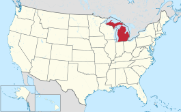
Sir yn nhalaith Michigan, Unol Daleithiau America yw Barry County. Cafodd ei henwi ar ôl William T. Barry. Sefydlwyd Barry County, Michigan ym 1829 a sedd weinyddol y sir (a elwir weithiau'n 'dref sirol' neu'n 'brifddinas y sir') yw Hastings, Michigan.
Mae ganddi arwynebedd o 1,494 cilometr sgwâr. Allan o'r arwynebedd hwn, y canran o ffurfiau dyfrol, megis llynnoedd ac afonydd, yw 4.2% . Yn ôl cyfrifiad y wlad, poblogaeth y sir yw: 62,423 (1 Ebrill 2020)[1]. Mewn cymhariaeth, yn 2016 roedd poblogaeth Caerdydd yn 361,462 a Rhyl tua 26,000.[2]
Mae'n ffinio gyda Ionia County, Kalamazoo County, Eaton County, Calhoun County, Allegan County, Kent County. Cedwir rhestr swyddogol o henebion ac adeiladau cofrestredig y sir yn: National Register of Historic Places listings in Michigan.
 |
|
| Map o leoliad y sir o fewn Michigan |
Lleoliad Michigan o fewn UDA |
Ceir sawl sir o’r un enw gan gynnwys:
Trefi mwyaf
Mae gan y sir yma boblogaeth o tua 62,423 (1 Ebrill 2020)[1]. Dyma rai o'r dinasoedd, trefi neu gymunedau mwyaf poblog y sir:
Rhestr Wicidata:
| Tref neu gymuned | Poblogaeth | Arwynebedd |
|---|---|---|
| Hastings, Michigan | 7095 7350[3] |
13.685848[4] 13.651353[3] |
| Middleville, Michigan | 3319[3] | 6.240433[4] 6.219434[3] |
| Nashville, Michigan | 1628[3] | 5.769892[4] 5.769915[3] |
| Delton | 872[3] | 5.766789[3][4] |
| Freeport, Michigan | 483[3] | 2.027484[3][4] |
| Woodland, Michigan | 425[3] | 2.110747[3][4] |
| Dowling | 374[3] | 16.270303[3][4] |
| Hickory Corners | 322[3] | 5.377433[3][4] |
| |||||
Cyfeiriadau
- ↑ 1.0 1.1 https://data.census.gov/cedsci/table?t=Populations%20and%20People&g=0100000US,%241600000&y=2020. Cyfrifiad yr Unol Daleithiau 2020. golygydd: Biwro Cyfrifiad yr Unol Daleithiau. dyddiad cyrchiad: 1 Ionawr 2022.
- ↑ statswales.gov.wales; adalwyd 25 Mawrth 2020.
- ↑ 3.00 3.01 3.02 3.03 3.04 3.05 3.06 3.07 3.08 3.09 3.10 3.11 3.12 3.13 3.14 3.15 https://www.census.gov/geographies/reference-files/time-series/geo/gazetteer-files.2010.html
- ↑ 4.0 4.1 4.2 4.3 4.4 4.5 4.6 4.7 2016 U.S. Gazetteer Files

