
Delwedd:Map showing counties under the new Kenyan constitution.gif

Maint llawn ((620 × 804 picsel, maint y ffeil: 56 KB, ffurf MIME: image/gif))
Crynodeb
| Disgrifiad |
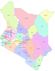
English: Areas that are covered by Counties in the new Kenya constitution |
| Dyddiad | |
| Ffynhonnell | https://opendata.go.ke/facet/counties |
| Awdur | Kenya Open Data Project |
Trwyddedu

|
The copyright holder of this work allows anyone to use it for any purpose including unrestricted redistribution, commercial use, and modification.
Usage notes:
|
All the works in the Kenya open data website are free for use either commercially or non commercially as it is stated at the terms and conditions of the website. I believe that this is a non commercial use on commons.
Hanes y ffeil
Cliciwch ar ddyddiad / amser i weld y ffeil fel ag yr oedd bryd hynny.
| Dyddiad / Amser | Bawdlun | Hyd a lled | Defnyddiwr | Sylw | |
|---|---|---|---|---|---|
| cyfredol | 06:48, 28 Mehefin 2012 | | 620 × 804 (56 KB) | Kagundu |
Cysylltiadau'r ffeil
Mae'r 1 tudalennau a ddefnyddir isod yn cysylltu i'r ddelwedd hon:
Defnydd cydwici y ffeil
Mae'r wicis eraill hyn yn defnyddio'r ffeil hon:
- Y defnydd ar ab.wikipedia.org
- Y defnydd ar ba.wikipedia.org
- Y defnydd ar bg.wikipedia.org
- Y defnydd ar bs.wikipedia.org
- Y defnydd ar cs.wikipedia.org
- Y defnydd ar en.wikipedia.org
- Y defnydd ar eo.wikipedia.org
- Y defnydd ar et.wikipedia.org
- Y defnydd ar eu.wikipedia.org
- Y defnydd ar fa.wikipedia.org
- Y defnydd ar fi.wikipedia.org
- Y defnydd ar fr.wikipedia.org
- Y defnydd ar he.wikipedia.org
- Y defnydd ar hu.wikipedia.org
- Y defnydd ar id.wikipedia.org
- Y defnydd ar incubator.wikimedia.org
- Y defnydd ar it.wikipedia.org
- Y defnydd ar ko.wikipedia.org
- Y defnydd ar ku.wikipedia.org
- Y defnydd ar my.wikipedia.org
- Y defnydd ar pl.wikipedia.org
- Y defnydd ar ru.wikipedia.org
- Кения
- Ньянза
- Западная провинция (Кения)
- Рифт-Валли
- Северо-Восточная провинция (Кения)
- Центральная провинция (Кения)
- Прибрежная провинция (Кения)
- Восточная провинция (Кения)
- Бусиа (округ, Кения)
- Найроби (провинция Кении)
- Административное деление Кении
- Гарисса (округ)
- Нарок (округ)
- Ваджир (округ)
- Шаблон:Административное деление Кении
- Занзойский округ
- Вихига (округ)
- Западный покотский округ
- Исиоло (округ)
Gweld rhagor o'r defnydd cydwici o'r ffeil hon.