
Delwedd:2022 Russian invasion of Ukraine.svg

Maint llawn (Ffeil SVG, maint mewn enw 2,199 × 1,478 picsel, maint y ffeil: 3.73 MB)
Rules for editing the map
|
| All edit warring, adding of unsourced information or performing a color change without consensus may result in the user being blocked. All contributions should first be discussed on the talk page. |
Crynodeb

|
This file may be updated to reflect new information. If you wish to use a specific version of the file without new updates being mirrored, please upload the required version as a separate file. |
| Disgrifiad |
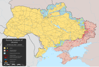
English: goresgyniad Wcráin gan Rwsia yn 2022 – ongoing military conflict in Eastern Europe since 2022 [] |
||
| Dyddiad | 24 Chwefror 2022 (first version) | ||
| Ffynhonnell |
Own work based on: Russo-Ukrainian conflict (2014-2022).svg by Rr016 & Ukraine adm location map improved.svg by Yakiv Gluck
|
||
| Awdur | Viewsridge | ||
| Diwygiadau eraill |
[]
|
||
| SVG genesis | This map is translated using SVG switch elements: all translations are stored in the same file.
|


.gif)

.gif)


_en.png)
_vi.png)
_ru.png)
.svg)
This file is translated using SVG <switch> elements. All translations are stored in the same file! Learn more.
For most Wikipedia projects, you can embed the file normally (without a To translate the text into your language, you can use the SVG Translate tool. Alternatively, you can download the file to your computer, add your translations using whatever software you're familiar with, and re-upload it with the same name. You will find help in Graphics Lab if you're not sure how to do this. |
Trwyddedu
- Mae'n rhydd i chi:
- rhannu – gallwch gopïo, dosbarthu a throsglwyddo'r gwaith
- ailwampio – gallwch addasu'r gwaith
- Ar yr amodau canlynol:
- cydnabyddiaeth – Mae'n rhaid i chi nodi manylion y gwaith hwn, rhoi dolen i'r drwydded, a nodi os y bu golygu arni, yn y modd a benwyd gan yr awdur neu'r trwyddedwr (ond heb awgrymu o gwbl eu bod yn eich cymeradwyo chi na'ch defnydd o'r gwaith).
- rhannu ar dermau tebyg – Os byddwch yn addasu'r gwaith hwn, neu yn ei drawsnewid, neu yn adeiladu arno, mae'n rhaid i chi ddosbarthu'r gwaith dan drwydded sy'n union yr un fath same a'r gwreiddiol.
Hanes y ffeil
Cliciwch ar ddyddiad / amser i weld y ffeil fel ag yr oedd bryd hynny.
| Dyddiad / Amser | Bawdlun | Hyd a lled | Defnyddiwr | Sylw | |
|---|---|---|---|---|---|
| cyfredol | 07:11, 27 Mai 2024 | | 2,199 × 1,478 (3.73 MB) | Physeters | clean up; for future reference, only the red shaded areas on the ISW map are shown as Russian controlled on this map |
| 09:14, 26 Mai 2024 |  | 2,199 × 1,478 (3.72 MB) | Hoben7599 | Per ISW | |
| 11:16, 22 Mai 2024 |  | 2,199 × 1,478 (3.32 MB) | Hoben7599 | File uploaded using svgtranslate tool (https://svgtranslate.toolforge.org/). Added translation for zh-hant. | |
| 05:49, 21 Mai 2024 |  | 2,199 × 1,478 (3.72 MB) | Physeters | Updates per the ISW, update Staromaiorske, Klishshchiivka, and Robotyne per the detailed map | |
| 04:00, 18 Mai 2024 |  | 2,199 × 1,478 (3.72 MB) | Physeters | Fix Bohudukhiv | |
| 20:47, 16 Mai 2024 |  | 2,199 × 1,478 (3.72 MB) | Physeters | Updates in Kharkiv Oblast per the ISW | |
| 04:40, 14 Mai 2024 |  | 2,199 × 1,478 (3.72 MB) | Physeters | fix Derhachi | |
| 05:36, 13 Mai 2024 |  | 2,199 × 1,478 (3.72 MB) | Alexiscoutinho | Updated Vovchansk per detailed map | |
| 02:49, 13 Mai 2024 |  | 2,199 × 1,478 (3.72 MB) | Physeters | Updates per the ISW; for future reference, sources (like SuriyakMaps) must first have their reliability vetted on the talk page before they can be used to update the map; at the moment, the only two verified sources are the ISW and the Detailed Map on Wikipedia | |
| 10:34, 12 Mai 2024 |  | 2,199 × 1,478 (3.31 MB) | BlackShadowG | File uploaded using svgtranslate tool (https://svgtranslate.toolforge.org/). Added translation for zh-tw. |
Cysylltiadau'r ffeil
Mae'r 3 tudalennau a ddefnyddir isod yn cysylltu i'r ddelwedd hon:
Defnydd cydwici y ffeil
Mae'r wicis eraill hyn yn defnyddio'r ffeil hon:
- Y defnydd ar af.wikipedia.org
- Y defnydd ar als.wikipedia.org
- Y defnydd ar am.wikipedia.org
- Y defnydd ar ang.wikipedia.org
- Y defnydd ar an.wikipedia.org
- Y defnydd ar ar.wikipedia.org
- Y defnydd ar ary.wikipedia.org
- Y defnydd ar arz.wikipedia.org
- Y defnydd ar ast.wikipedia.org
- Y defnydd ar azb.wikipedia.org
- Y defnydd ar az.wikipedia.org
- Y defnydd ar bat-smg.wikipedia.org
- Y defnydd ar bcl.wikipedia.org
- Y defnydd ar be-tarask.wikipedia.org
- Y defnydd ar be.wikipedia.org
- Y defnydd ar bg.wikipedia.org
- Y defnydd ar bh.wikipedia.org
- Y defnydd ar bn.wikipedia.org
- Y defnydd ar br.wikipedia.org
- Y defnydd ar bs.wikipedia.org
- Y defnydd ar bxr.wikipedia.org
Gweld rhagor o'r defnydd cydwici o'r ffeil hon.