
Delwedd:Piccadilly Station Manchester - geograph.org.uk - 692981.jpg
Wedi ei chwyddo hyd yr eithaf.
Piccadilly_Station_Manchester_-_geograph.org.uk_-_692981.jpg ((800 × 534 picsel, maint y ffeil: 100 KB, ffurf MIME: image/jpeg))
Crynodeb
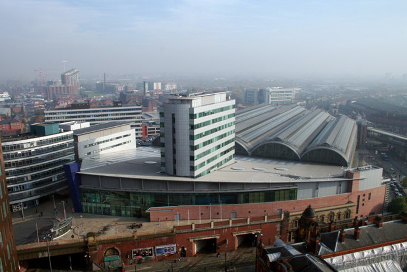
| Disgrifiad |
English: Piccadilly Station Manchester Store Street Station opened in 1842 as the terminus of the Manchester and Birmingham Railway. As the rail network expanded it became London Road Station in 1849. It was rebuilt and became Manchester Piccadilly in 1960 for the new London Midland Region electric service to London. The two openings visible at the bottom centre of the photograph are for the Manchester Metrolink trams which went into service in 1992. The station was extensively modified for the 2002 Commonwealth Games. |
| Dyddiad | |
| Ffynhonnell | From geograph.org.uk |
| Awdur | Peter Hyde |
| Cydnabyddiaeth (required by the license) | Peter Hyde / Piccadilly Station Manchester / |
| Camera location | | View this and other nearby images on: OpenStreetMap |
|---|
_heading:90.00&language=cy)
| Object location | | View this and other nearby images on: OpenStreetMap |
|---|
_heading:90.00&language=cy)
Trwyddedu

|
This image was taken from the Geograph project collection. See this photograph's page on the Geograph website for the photographer's contact details. The copyright on this image is owned by Peter Hyde and is licensed for reuse under the Creative Commons Attribution-ShareAlike 2.0 license.
|
Trwyddedir y ffeil hon yn ôl termau'r drwydded Creative Commons Attribution-Share Alike 2.0 Generic.
Cydnabyddiaeth: Peter Hyde
- Mae'n rhydd i chi:
- rhannu – gallwch gopïo, dosbarthu a throsglwyddo'r gwaith
- ailwampio – gallwch addasu'r gwaith
- Ar yr amodau canlynol:
- cydnabyddiaeth – Mae'n rhaid i chi nodi manylion y gwaith hwn, rhoi dolen i'r drwydded, a nodi os y bu golygu arni, yn y modd a benwyd gan yr awdur neu'r trwyddedwr (ond heb awgrymu o gwbl eu bod yn eich cymeradwyo chi na'ch defnydd o'r gwaith).
- rhannu ar dermau tebyg – Os byddwch yn addasu'r gwaith hwn, neu yn ei drawsnewid, neu yn adeiladu arno, mae'n rhaid i chi ddosbarthu'r gwaith dan drwydded sy'n union yr un fath same a'r gwreiddiol.
Hanes y ffeil
Cliciwch ar ddyddiad / amser i weld y ffeil fel ag yr oedd bryd hynny.
| Dyddiad / Amser | Bawdlun | Hyd a lled | Defnyddiwr | Sylw | |
|---|---|---|---|---|---|
| cyfredol | 14:41, 17 Ebrill 2014 | | 800 × 534 (100 KB) | G-13114 | resized |
| 05:44, 8 Chwefror 2011 |  | 640 × 427 (67 KB) | GeographBot | == {{int:filedesc}} == {{Information |description={{en|1=Piccadilly Station Manchester Store Street Station opened in 1842 as the terminus of the Manchester and Birmingham Railway. As the rail network expanded it became London Road Station in 1849. It was |
Cysylltiadau'r ffeil
Nid oes tudalennau'n defnyddio'r ffeil hon.
Defnydd cydwici y ffeil
Mae'r wicis eraill hyn yn defnyddio'r ffeil hon:
- Y defnydd ar ar.wikipedia.org
- Y defnydd ar arz.wikipedia.org
- Y defnydd ar be-tarask.wikipedia.org
- Y defnydd ar cs.wikipedia.org
- Y defnydd ar de.wikipedia.org
- Y defnydd ar en.wikipedia.org
- Manchester
- North West England
- Manchester Piccadilly station
- Portal:North West England
- Transport in Manchester
- Architecture of Manchester
- List of busiest railway stations in Great Britain (2021–22)
- The Warehouse Project
- Manchester station group
- List of busiest railway stations in Great Britain (2020–21)
- List of busiest railway stations in Great Britain (2019–20)
- List of busiest railway stations in Great Britain
- Y defnydd ar es.wikipedia.org
- Y defnydd ar fa.wikipedia.org
- Y defnydd ar fr.wikivoyage.org
- Y defnydd ar he.wikivoyage.org
- Y defnydd ar hu.wikipedia.org
- Y defnydd ar id.wikipedia.org
- Y defnydd ar it.wikivoyage.org
- Y defnydd ar ja.wikipedia.org
- Y defnydd ar nl.wikipedia.org
- Y defnydd ar www.wikidata.org
- Y defnydd ar yi.wikipedia.org
- Y defnydd ar zh.wikipedia.org