
Delwedd:Pestilence spreading 1347-1351 europe.png

Maint llawn ((1,280 × 1,387 picsel, maint y ffeil: 350 KB, ffurf MIME: image/png))
| Disgrifiad |
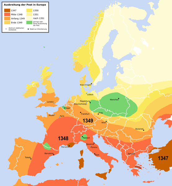
English: Spreading of the en:Black Death in Europe between 1347 and 1351, apparently copied from a work called "Atlas zur Weltgeschichte" (perhaps dtv-Atlas? If so, Kinder and Hilgemann (eds.), dtv-Atlas zur Weltgeschichte was published in 35(!) editions between 1964 and 2002, and it would be crucial to know which edition we are basing this on).
The details of the map are to be taken with a large grain of salt. It is roughly compatible with this Britannica map (copy, dated 1994), but the details vary significantly. Other significant differences exist with this map (an unreferenced scan of a professional publication), where e.g. the area of Poland/Silesia marked "unaffected" in this map is part of a much larger area marked as "Area for which there is insufficient information". Here is another map with a somewhat more conservative epistemology, referenced to "insecta-inspecta.com", where it was posted in 2000 (and therefore uninfluenced by the 2005 upload of this map). An academically published map for comparison: [1] cited to: D. Sherman and J. Salisbury, The West in the World: Volume I to 1715. McGraw-Hill, Boston, 3rd edition (2008), not necessarily better than the Britannica map, as it is a rough sketched used for the purposes of some argument about network theory, and not a medievalist publication dedicated to the history of the Black Death as such.Deutsch: Ausbreitung der de:Pest in Europa zwischen 1347 und 1351 |
| Dyddiad | |
| Ffynhonnell | "Atlas zur Weltgeschichte"(?) |
| Awdur | Roger_Zenner |
| Caniatâd (Ailddefnyddio'r ffeil hon) |
Creative Commons by/sa/de |
| Diwygiadau eraill |
[] Better than many files each for one language is to create one multilanguaged file (SVG switch option).
|


- Version 1.1
- Changelog: 1.0: new map -> 1.1: more details, color changes, more cities
- Mae'n rhydd i chi:
- rhannu – gallwch gopïo, dosbarthu a throsglwyddo'r gwaith
- ailwampio – gallwch addasu'r gwaith
- Ar yr amodau canlynol:
- cydnabyddiaeth – Mae'n rhaid i chi nodi manylion y gwaith hwn, rhoi dolen i'r drwydded, a nodi os y bu golygu arni, yn y modd a benwyd gan yr awdur neu'r trwyddedwr (ond heb awgrymu o gwbl eu bod yn eich cymeradwyo chi na'ch defnydd o'r gwaith).
- rhannu ar dermau tebyg – Os byddwch yn addasu'r gwaith hwn, neu yn ei drawsnewid, neu yn adeiladu arno, mae'n rhaid i chi ddosbarthu'r gwaith dan drwydded sy'n union yr un fath same a'r gwreiddiol.

Hanes y ffeil
Cliciwch ar ddyddiad / amser i weld y ffeil fel ag yr oedd bryd hynny.
| Dyddiad / Amser | Bawdlun | Hyd a lled | Defnyddiwr | Sylw | |
|---|---|---|---|---|---|
| cyfredol | 22:42, 3 Ebrill 2016 | | 1,280 × 1,387 (350 KB) | Poeticbent | made the map readable again |
| 01:32, 24 Mai 2015 |  | 1,280 × 1,387 (330 KB) | Alphathon | Removed border in Northern Serbia (seems roughly correspond to the Autonomous Province of Vojvodina; shouldn't be on there regardless). Added border between Montenegro and Serbia (which separated in 2006). Also added Kosovo border. | |
| 13:18, 21 Ionawr 2010 |  | 1,280 × 1,387 (304 KB) | Chesnok | deleted artificial Rybinsk reservoir and reservoirs on Dnieper | |
| 03:46, 3 Ebrill 2005 |  | 1,280 × 1,387 (378 KB) | Roger Zenner | ||
| 03:30, 3 Ebrill 2005 |  | 1,280 × 1,354 (394 KB) | Roger Zenner | ||
| 02:17, 3 Ebrill 2005 |  | 1,280 × 1,346 (373 KB) | Roger Zenner | *'''english''': spreading of the en:pest in Europe between 1347 and 1351 *'''deutsch''': Ausbreitung der de:Pest in Europa zwischen 1347 und 1351 *License: Creative Commons by/sa/de *Author: Roger_Zenner *Date: 2005/03/04 |
Cysylltiadau'r ffeil
Mae'r 1 tudalennau a ddefnyddir isod yn cysylltu i'r ddelwedd hon:
Defnydd cydwici y ffeil
Mae'r wicis eraill hyn yn defnyddio'r ffeil hon:
- Y defnydd ar als.wikipedia.org
- Y defnydd ar an.wikipedia.org
- Y defnydd ar arz.wikipedia.org
- Y defnydd ar azb.wikipedia.org
- Y defnydd ar bg.wikipedia.org
- Y defnydd ar de.wikipedia.org
- Y defnydd ar de.wikibooks.org
- Y defnydd ar frr.wikipedia.org
- Y defnydd ar fr.wikipedia.org
- Y defnydd ar gl.wikipedia.org
- Y defnydd ar hu.wikipedia.org
- Y defnydd ar hy.wikipedia.org
- Y defnydd ar ia.wikipedia.org
- Y defnydd ar incubator.wikimedia.org
- Y defnydd ar io.wikipedia.org
- Y defnydd ar lad.wikipedia.org
- Y defnydd ar la.wikipedia.org
- Y defnydd ar nl.wikipedia.org
- Y defnydd ar sl.wikipedia.org
- Y defnydd ar www.wikidata.org
- Y defnydd ar zh-min-nan.wikipedia.org