
Delwedd:Map of the Territory of the Dobunni.svg

Maint rhagolwg PNG o ffeil SVG yw: 424 × 600 picsel. Eglurdebau eraill: 170 × 240 picsel | 339 × 480 picsel | 543 × 768 picsel | 724 × 1,024 picsel | 1,448 × 2,048 picsel | 744 × 1,052 picsel.
Maint llawn (Ffeil SVG, maint mewn enw 744 × 1,052 picsel, maint y ffeil: 148 KB)
| Disgrifiad |
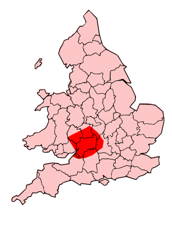
English: A map showing the territory of the Dobunni tribe overlayed in red in the context of the modern county boundaries of England and wales |
| Dyddiad | (UTC) |
| Ffynhonnell | |
| Awdur |
|
| Diwygiadau eraill | Derivative works of this file: Map of the Territory of the Corieltauvi.svg |
.svg)
.png)
| This is a retouched picture, which means that it has been digitally altered from its original version. Modifications: Now showing Dobunnii territory. The original can be viewed here: Map of the Territory of the Cornovii (Midlands).svg:
|
Yr wyf fi, deiliad yr hawlfraint ar y gwaith hwn, yn ei gyhoeddi yn ôl termau'r trwyddedau a ganlyn:
Trwyddedir y ffeil hon yn ôl termau'r drwydded Creative Commons Attribution-Share Alike 3.0 Unported.
- Mae'n rhydd i chi:
- rhannu – gallwch gopïo, dosbarthu a throsglwyddo'r gwaith
- ailwampio – gallwch addasu'r gwaith
- Ar yr amodau canlynol:
- cydnabyddiaeth – Mae'n rhaid i chi nodi manylion y gwaith hwn, rhoi dolen i'r drwydded, a nodi os y bu golygu arni, yn y modd a benwyd gan yr awdur neu'r trwyddedwr (ond heb awgrymu o gwbl eu bod yn eich cymeradwyo chi na'ch defnydd o'r gwaith).
- rhannu ar dermau tebyg – Os byddwch yn addasu'r gwaith hwn, neu yn ei drawsnewid, neu yn adeiladu arno, mae'n rhaid i chi ddosbarthu'r gwaith dan drwydded sy'n union yr un fath same a'r gwreiddiol.

|
Caniateir copïo, dosbarthu a/neu golygu'r ddogfen hon yn ôl telerau'r Drwydded Ddogfennaeth Rydd GNU, Fersiwn 1.2 neu unrhyw fersiwn diweddarach a gyhoeddwyd gan y Free Software Foundation; yn cynnwys dim Adrannau Di-syfl, dim Testunau Clawr Blaen, a dim Testunau Clawr Cefn. Cynhwysir copi o'r drwydded hon yn yr adran Trwydded Ddogfennaeth Rydd GNU". |
Gallwch ddewis y drwydded y mynnwch.
Cofnod lòg yr uwchlwythiad gwreiddiol
This image is a derivative work of the following images:
- File:Map_of_the_Territory_of_the_Cornovii_(Midlands).svg licensed with Cc-by-sa-3.0, GFDL
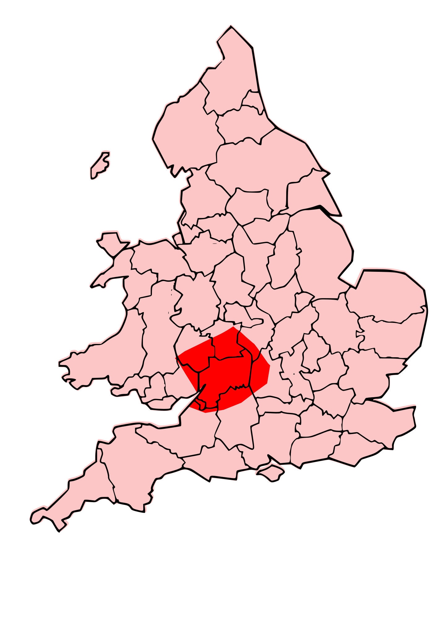
- 2009-09-25T00:09:57Z Jpb1301 744x1052 (153095 Bytes) {{Information |Description={{en|1=A map showing the territory of the Cornovii tribe overlayed in red in the context of the modern county boundaries of England and wales}} |Source=*[[:File:Map_of_the_Territory_of_the_Cornovii_
Uploaded with derivativeFX
Hanes y ffeil
Cliciwch ar ddyddiad / amser i weld y ffeil fel ag yr oedd bryd hynny.
| Dyddiad / Amser | Bawdlun | Hyd a lled | Defnyddiwr | Sylw | |
|---|---|---|---|---|---|
| cyfredol | 19:47, 13 Hydref 2009 | | 744 × 1,052 (148 KB) | Jpb1301 | {{Information |Description={{en|1=A map showing the territory of the Dobunni tribe overlayed in red in the context of the modern county boundaries of England and wales}} |Source=*File:Map_of_the_Territory_of_the_Dobunni.svg |Date=2009-10-13 19:46 (U |
| 17:38, 13 Hydref 2009 |  | 744 × 1,052 (148 KB) | Jpb1301 | {{Information |Description={{en|1=A map showing the territory of the Dobunni tribe overlayed in red in the context of the modern county boundaries of England and wales}} |Source=*File:Map_of_the_Territory_of_the_Cornovii_(Midlands).svg |Date=2009-10 |
.svg)
Cysylltiadau'r ffeil
Mae'r 1 tudalennau a ddefnyddir isod yn cysylltu i'r ddelwedd hon:
Defnydd cydwici y ffeil
Mae'r wicis eraill hyn yn defnyddio'r ffeil hon: