
Delwedd:Hurricane Katrina August 28 2005 NASA.jpg

Maint llawn ((6,200 × 8,000 picsel, maint y ffeil: 9.5 MB, ffurf MIME: image/jpeg))
Crynodeb
| Disgrifiad |
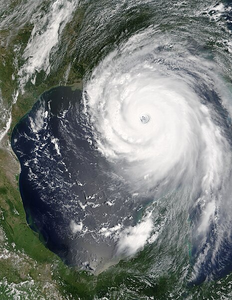
“Katrina is comparable in intensity to Hurricane Camille of 1969, only larger,” warned the National Hurricane Center on Sunday, August 28, 2005. By this time, Hurricane Katrina was set to become one of the most powerful storms to strike the United States, with winds of 257 kilometers per hour (160 miles per hour) and stronger gusts. The air pressure, another indicator of hurricane strength, at the center of this Category 5 storm measured 902 millibars, the fourth lowest air pressure on record for an Atlantic storm. The lower the air pressure, the more powerful the storm. Two hours after the National Hurricane Center issued their warning, the Moderate Resolution Imaging Spectroradiometer (MODIS) captured this image from NASA’s Terra satellite at 1:00 p.m. Eastern Daylight Savings Time. The massive storm covers much of the Gulf of Mexico, spanning from the U.S. coast to the Yucatan Peninsula. |
|||||
| Dyddiad | ||||||
| Ffynhonnell | http://visibleearth.nasa.gov/view_rec.php?id=7938 | |||||
| Awdur | Jeff Schmaltz, MODIS Rapid Response Team, NASA/GSFC | |||||
| Caniatâd (Ailddefnyddio'r ffeil hon) |
|

Hanes y ffeil
Cliciwch ar ddyddiad / amser i weld y ffeil fel ag yr oedd bryd hynny.
| Dyddiad / Amser | Bawdlun | Hyd a lled | Defnyddiwr | Sylw | |
|---|---|---|---|---|---|
| cyfredol | 21:21, 18 Ebrill 2021 | | 6,200 × 8,000 (9.5 MB) | FleurDeOdile | Reverted to version as of 21:42, 18 October 2010 (UTC) how dare you do that to an iconic picture |
| 19:42, 17 Ebrill 2021 |  | 3,250 × 4,076 (2.02 MB) | Pilas24 | Straightened | |
| 21:42, 18 Hydref 2010 |  | 6,200 × 8,000 (9.5 MB) | Potapych | moved picture to new location File:Hurricane Katrina August 28 2005 cropped.jpg | |
| 00:43, 30 Medi 2010 |  | 5,000 × 5,000 (5.45 MB) | HurricaneSpin | Reverted to version as of 05:28, 18 September 2010 | |
| 17:17, 18 Medi 2010 |  | 6,200 × 8,000 (9.5 MB) | Potapych | Upload it as a new file, please. The other one has a black bar in the corner and very little left of the scene | |
| 05:28, 18 Medi 2010 |  | 5,000 × 5,000 (5.45 MB) | HurricaneSpin | It's always better to have image facing north | |
| 03:19, 18 Medi 2010 |  | 6,200 × 8,000 (9.5 MB) | Potapych | Reverted to version as of 16:42, 26 August 2006 This one is far superior to all the subsequent versions | |
| 18:50, 17 Medi 2010 |  | 5,000 × 5,000 (5.45 MB) | HurricaneSpin | Cropped little bit more. | |
| 18:16, 17 Medi 2010 |  | 6,500 × 7,000 (10.18 MB) | HurricaneSpin | North orientation and cropped. | |
| 22:32, 7 Hydref 2008 |  | 6,200 × 8,000 (9.5 MB) | Infrogmation | Reverted to version as of 16:42, 26 August 2006 |
Cysylltiadau'r ffeil
Mae'r 2 tudalennau a ddefnyddir isod yn cysylltu i'r ddelwedd hon:
Defnydd cydwici y ffeil
Mae'r wicis eraill hyn yn defnyddio'r ffeil hon:
- Y defnydd ar af.wikipedia.org
- Y defnydd ar ar.wikipedia.org
- Y defnydd ar bg.wikipedia.org
- Y defnydd ar ca.wikipedia.org
- Y defnydd ar ckb.wikipedia.org
- Y defnydd ar cs.wikipedia.org
- Y defnydd ar da.wikipedia.org
- Y defnydd ar de.wikipedia.org
- Y defnydd ar de.wikiversity.org
- Y defnydd ar de.wiktionary.org
- Y defnydd ar el.wikipedia.org
- Y defnydd ar en.wikipedia.org
- Gulf Coast of the United States
- 2005 in the United States
- Wikipedia:Today's featured article/September 29, 2006
- Timeline of the 2005 Atlantic hurricane season
- User:Jdorje/2005 Atlantic hurricane season/2005 Atlantic hurricane season storms
- Atlantic hurricane
- Wikipedia:Today's featured article/September 2006
- Sunglint
- List of Atlantic hurricane records
- Portal:Tropical cyclones/Featured article/Hurricane Katrina
- User:Nauticashades/FPC
- Talk:Hurricane Katrina/Archive 6
- Wikipedia:Featured picture candidates/October-2006
- Wikipedia:Featured picture candidates/Hurricane Katrina
- Portal:Tropical cyclones/Anniversaries/August
- Portal:Tropical cyclones/Anniversaries/August/29
- User:KrakatoaKatie/CalendarAugust
- Name-letter effect
- Wikipedia:Featured picture candidates/March-2008
- Wikipedia:Featured picture candidates/Hurricane Katrina August 28 2005 NASA.jpg
- Portal:Tropical cyclones/Featured article
- Wikipedia:Graphics Lab/Photography workshop/Archive/Jun 2010
- Wikipedia talk:WikiProject Tropical cyclones/Archive 23
- User:IPhonehurricane95/Picture of the day/Hurricane Katrina
- User:LightandDark2000/My Notable Storms
- User:SuperNascar 1991
- Wikipedia:Top 25 Report/October 2 to 8, 2016
Gweld rhagor o'r defnydd cydwici o'r ffeil hon.