
Delwedd:Grimsby Dock Tower.jpg
Maint llawn ((523 × 640 picsel, maint y ffeil: 99 KB, ffurf MIME: image/jpeg))
Crynodeb
This is a photo of listed building number 1379870. |
| Camera location | | View this and other nearby images on: OpenStreetMap |
|---|
| Object location | | View this and other nearby images on: OpenStreetMap |
|---|
_region:GB-GBN_heading:22.00&language=cy)
| Disgrifiad |
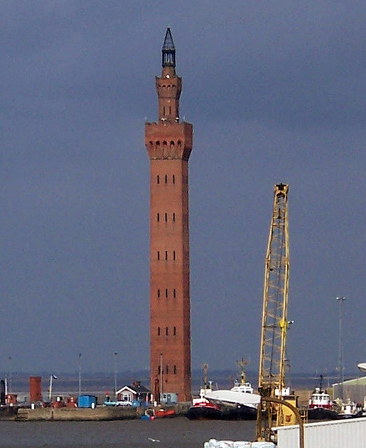
Grimsby Dock Tower Note that the Grimsby tower isn't a hydraulic accumulator (it's in the category because it's an important part of their history). Towers such as Grimsby achieved high pressures simply by their height, expensive though these were to construct. It was soon realised that a pressurised cistern with a heavy iron or concrete weight on it gave the same results, at much less cost.
For more information on the tower see Link |
| Dyddiad | |
| Ffynhonnell | Geograph |
| Awdur | David Wright (Uploaded by User:PeterJewell) |
| Caniatâd (Ailddefnyddio'r ffeil hon) |
Creative Commons: Attribution-ShareAlike 2.0 |
Trwyddedu

|
This image was taken from the Geograph project collection. See this photograph's page on the Geograph website for the photographer's contact details. The copyright on this image is owned by David Wright and is licensed for reuse under the Creative Commons Attribution-ShareAlike 2.0 license.
|
- Mae'n rhydd i chi:
- rhannu – gallwch gopïo, dosbarthu a throsglwyddo'r gwaith
- ailwampio – gallwch addasu'r gwaith
- Ar yr amodau canlynol:
- cydnabyddiaeth – Mae'n rhaid i chi nodi manylion y gwaith hwn, rhoi dolen i'r drwydded, a nodi os y bu golygu arni, yn y modd a benwyd gan yr awdur neu'r trwyddedwr (ond heb awgrymu o gwbl eu bod yn eich cymeradwyo chi na'ch defnydd o'r gwaith).
- rhannu ar dermau tebyg – Os byddwch yn addasu'r gwaith hwn, neu yn ei drawsnewid, neu yn adeiladu arno, mae'n rhaid i chi ddosbarthu'r gwaith dan drwydded sy'n union yr un fath same a'r gwreiddiol.
Hanes y ffeil
Cliciwch ar ddyddiad / amser i weld y ffeil fel ag yr oedd bryd hynny.
| Dyddiad / Amser | Bawdlun | Hyd a lled | Defnyddiwr | Sylw | |
|---|---|---|---|---|---|
| cyfredol | 00:41, 17 Gorffennaf 2007 | | 523 × 640 (99 KB) | PeterJewell | {{Information |Description= |Source= |Date= |Author= |Permission= |other_versions= }} |
Cysylltiadau'r ffeil
Mae'r 1 tudalennau a ddefnyddir isod yn cysylltu i'r ddelwedd hon:
Defnydd cydwici y ffeil
Mae'r wicis eraill hyn yn defnyddio'r ffeil hon:
- Y defnydd ar ar.wikipedia.org
- Y defnydd ar arz.wikipedia.org
- Y defnydd ar azb.wikipedia.org
- Y defnydd ar be.wikipedia.org
- Y defnydd ar ca.wikipedia.org
- Y defnydd ar ceb.wikipedia.org
- Y defnydd ar da.wikipedia.org
- Y defnydd ar de.wikipedia.org
- Y defnydd ar de.wikivoyage.org
- Y defnydd ar en.wikipedia.org
- Y defnydd ar en.wikivoyage.org
- Y defnydd ar eo.wikipedia.org
- Y defnydd ar es.wikipedia.org
- Y defnydd ar eu.wikipedia.org
- Y defnydd ar fa.wikipedia.org
- Y defnydd ar fi.wikipedia.org
- Y defnydd ar frr.wikipedia.org
- Y defnydd ar fr.wikipedia.org
- Y defnydd ar ga.wikipedia.org
- Y defnydd ar he.wikipedia.org
- Y defnydd ar id.wikipedia.org
- Y defnydd ar it.wikipedia.org
- Y defnydd ar it.wikivoyage.org
- Y defnydd ar ko.wikipedia.org
- Y defnydd ar lld.wikipedia.org
- Y defnydd ar lt.wikipedia.org
- Y defnydd ar nl.wikipedia.org
- Y defnydd ar nn.wikipedia.org
- Y defnydd ar no.wikipedia.org
- Y defnydd ar ro.wikipedia.org
- Y defnydd ar ru.wikipedia.org
- Y defnydd ar simple.wikipedia.org
- Y defnydd ar sr.wikipedia.org
- Y defnydd ar sv.wikipedia.org
- Y defnydd ar tt.wikipedia.org
- Y defnydd ar uk.wikipedia.org
- Y defnydd ar ur.wikipedia.org
- Y defnydd ar www.wikidata.org
- Y defnydd ar zh.wikipedia.org