Delwedd:Breakup of Yugoslavia.gif
Ni chefnogir cynnwys y dudalen mewn ieithoedd eraill.
Oddi ar Wicipedia

Maint llawn((1,545 × 1,242 picsel, maint y ffeil: 187 KB, ffurf MIME: image/gif), dolennog, 14 ffrâm, 44e)

Daw'r ffeil hon o Comin Wikimedia a gellir ei defnyddio gan brosiectau eraill. Dangosir isod y disgrifiad sydd ar dudalen ddisgrifio'r ffeil yno.

This image could be re-created using vector graphics as an SVG file. This has several advantages; see Commons:Media for cleanup for more information. If an SVG form of this image is available, please upload it and afterwards replace this template with {{vector version available|new image name}}. It is recommended to name the SVG file "Breakup of Yugoslavia.svg" - then the template Vector version available (or Vva) does not need the new image name parameter.

Crynodeb

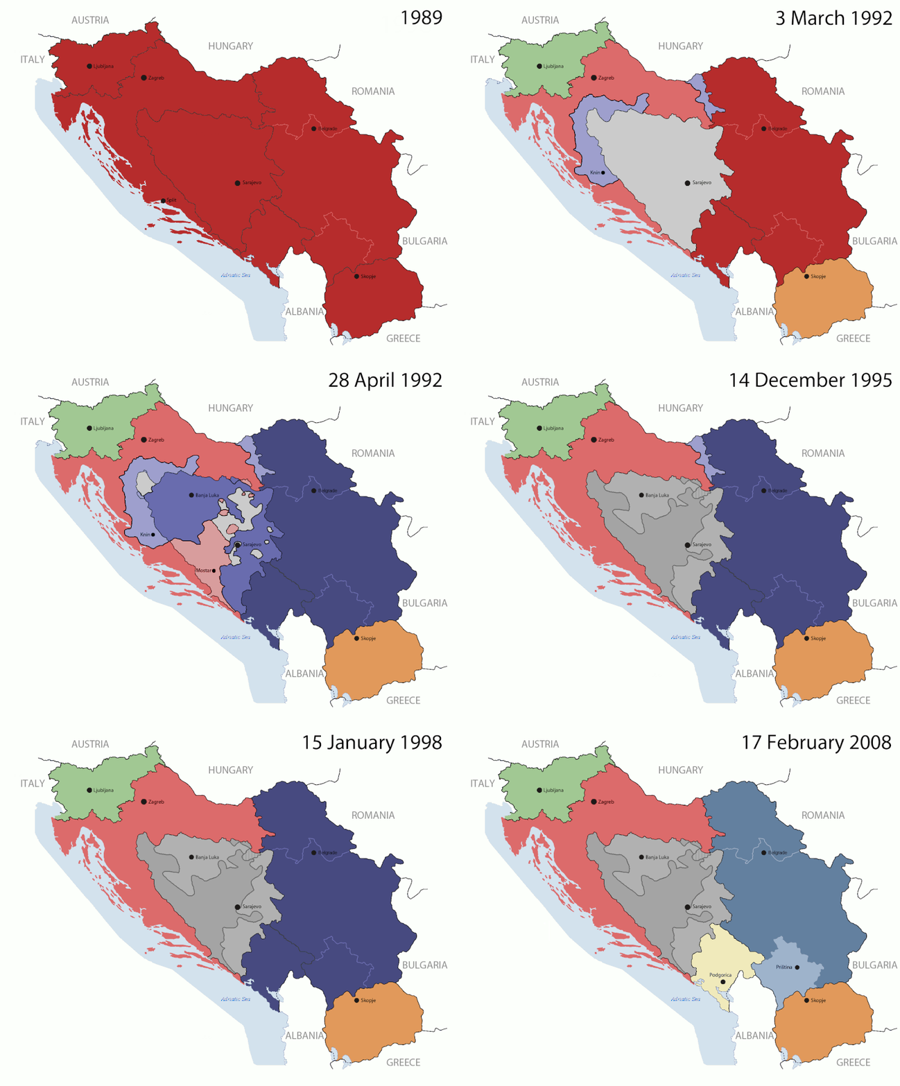
Key:

Yugoslavia (1943–1992) SFR Yugoslavia
Croatia (1991–present) Croatia
Herzeg-Bosnia (1992–1994)
UNTAES (1996–1998)
Federal Republic of Yugoslavia / Serbia and Montenegro (1992–2006) Serbia and Montenegro
Republika Srpska (1992–present) Republika Srpska
Serbian Krajina (1991–1995/96)
Republic of Bosnia and Herzegovina (1992–1995)
Bosnia and Herzegovina (1998–present) Bosnia and Herzegovina
Western Bosnia (1993–1995)
Serbia (2006–present) Serbia
Kosovo (under UNMIK control 1999–present; declaration of independence 2008) Kosovo
Montenegro (2006–present) Montenegro
Macedonia (1991–present) Macedonia
Slovenia (1991–present) Slovenia


Disgrifiad

This is an animated GIF that shows the stages of the breakup of the SFR Yugoslavia in the 90's and 2000's. The map based off Morwen's map of the divisions of the SFRY, Which is licensed by the GFDL. The source for the dates of independence is the CIA World Factbook. These maps do not now show the Inter-Entity Boundary Line (IEBL) and/or the entities that are separated by it. The IEBL has been drawn based on this CIA map; the Brčko District has been drawn based on Image:BH municipality location.gif, by user:Ante Perkovic. I might add them in the future.

Since the original map was GFDL, this image is as well.

A map depicting Kosovo's final status is ready once it takes effect.


Changelog for versions 2/3:

Here are some changes in this new build of the map:

  • The Kosovo boundary has been given a shade of red instead of the previous UN blue since they are a province of Serbia under UNIMIK control.
  • Montenegro's color has been changed to a golden shade close to what's on the flag.
  • The IEBL and the Brčko District has been redrawn because I deleted the original map; the color for the Republika Srpska is lighter.
  • The dates are at the top left hand corner of the map instead of the bottom.
  • I have taken a new approach as to the boundaries. Each part of Yugoslavia now shows the boundary on the maps starting the year they broke away. I feel this change helps readers understand the breakup better.
  • The SFRY and the FRY are in different shades since the FRY was never accepted as the successor to the former by the UN.
  • The colors for the entities of BiH have been removed as to not confuse people into thinking that they are independent states. What remains is the IEBL with both entities in green.
  • The Kosovo boundary is finally in hash marks!
  • The Brčko District has been removed. The sale is too small to show accurately.

Changelog for version 4:

  • The map is larger!
  • The image has been rebuilt to include the eastern part of FYR Macedonia.
  • The image has been updated to take in Kosovo's new status.
  • The IEBL is now a darker line.
  • Montenegro, Kosovo, and FRY/SCG/Serbia have new colors!

Changelog for version 5:

  • Rebuilt
  • Larger map: size of base image
  • Accurate Inter-Entity Boundary Line
Dyddiad 24 July 2006 (orginal upload date)
Ffynhonnell Made by Hoshie; see above for more details on sources.
Awdur Hoshie
Diwygiadau eraill

Trwyddedu

GNU head Caniateir copïo, dosbarthu a/neu golygu'r ddogfen hon yn ôl telerau'r Drwydded Ddogfennaeth Rydd GNU, Fersiwn 1.2 neu unrhyw fersiwn diweddarach a gyhoeddwyd gan y Free Software Foundation; yn cynnwys dim Adrannau Di-syfl, dim Testunau Clawr Blaen, a dim Testunau Clawr Cefn. Cynhwysir copi o'r drwydded hon yn yr adran Trwydded Ddogfennaeth Rydd GNU".
w:en:Creative Commons
cydnabyddiaeth rhannu ar dermau tebyg
Trwyddedir y ffeil hon yn ôl termau'r drwydded Creative Commons Attribution-Share Alike 3.0 Unported.
Mae'n rhydd i chi:
  • rhannu – gallwch gopïo, dosbarthu a throsglwyddo'r gwaith
  • ailwampio – gallwch addasu'r gwaith
Ar yr amodau canlynol:
  • cydnabyddiaeth – Mae'n rhaid i chi nodi manylion y gwaith hwn, rhoi dolen i'r drwydded, a nodi os y bu golygu arni, yn y modd a benwyd gan yr awdur neu'r trwyddedwr (ond heb awgrymu o gwbl eu bod yn eich cymeradwyo chi na'ch defnydd o'r gwaith).
  • rhannu ar dermau tebyg – Os byddwch yn addasu'r gwaith hwn, neu yn ei drawsnewid, neu yn adeiladu arno, mae'n rhaid i chi ddosbarthu'r gwaith dan drwydded sy'n union yr un fath same a'r gwreiddiol.
Ychwangwyd y nod trwyddedu hwn wrth y ffeil hon yn ran o'r gwaith o ddiweddaru trwyddedau GFDL.

Captions

Add a one-line explanation of what this file represents

Items portrayed in this file

yn portreadu

MIME type Saesneg

image/gif

checksum Saesneg

05ca2aefea8406b809968643552d5095c847a42f

data size Saesneg

191,625 byte

44 eiliad

1,242 pixel

1,545 pixel

Hanes y ffeil

Cliciwch ar ddyddiad / amser i weld y ffeil fel ag yr oedd bryd hynny.

(Diweddaraf | Cynharaf) Dangos (y 10 mwy diweddar.) () (10 | 20 | 50 | 100 | 250 | 500).
Dyddiad / AmserBawdlunHyd a lledDefnyddiwrSylw
cyfredol07:40, 17 Gorffennaf 2016Bawdlun y fersiwn am 07:40, 17 Gorffennaf 20161,545 × 1,242 (187 KB)מפתח-רשימהReverted to version as of 17:22, 21 August 2015 (UTC)
17:22, 21 Awst 2015Bawdlun y fersiwn am 17:22, 21 Awst 20151,463 × 1,158 (1.81 MB)BraganzaReverted to version as of 03:57, 19 January 2010
17:22, 21 Awst 2015Bawdlun y fersiwn am 17:22, 21 Awst 20151,545 × 1,242 (187 KB)BraganzaReverted to version as of 01:02, 19 December 2011
17:15, 21 Awst 2015Bawdlun y fersiwn am 17:15, 21 Awst 2015120 × 95 (3 KB)Braganza03:57, 19. Jan. 2010
01:02, 19 Rhagfyr 2011Bawdlun y fersiwn am 01:02, 19 Rhagfyr 20111,545 × 1,242 (187 KB)DIREKTORAdded details
18:09, 27 Gorffennaf 2011Bawdlun y fersiwn am 18:09, 27 Gorffennaf 20111,545 × 1,242 (170 KB)DIREKTORSmall fixes
17:28, 27 Gorffennaf 2011Bawdlun y fersiwn am 17:28, 27 Gorffennaf 20111,545 × 1,242 (171 KB)DIREKTORAdded UNMIK
16:38, 27 Gorffennaf 2011Bawdlun y fersiwn am 16:38, 27 Gorffennaf 20111,545 × 1,242 (165 KB)DIREKTORDates for the last two frames.
12:10, 27 Gorffennaf 2011Bawdlun y fersiwn am 12:10, 27 Gorffennaf 20111,545 × 1,242 (149 KB)DIREKTORLighter shade for country names
16:59, 26 Gorffennaf 2011Bawdlun y fersiwn am 16:59, 26 Gorffennaf 20111,545 × 1,242 (170 KB)DIREKTORHigher res plus details
(Diweddaraf | Cynharaf) Dangos (y 10 mwy diweddar.) () (10 | 20 | 50 | 100 | 250 | 500).

Mae'r 1 tudalennau a ddefnyddir isod yn cysylltu i'r ddelwedd hon:

Defnydd cydwici y ffeil

Mae'r wicis eraill hyn yn defnyddio'r ffeil hon:

Gweld rhagor o'r defnydd cydwici o'r ffeil hon.

Metadata