
Delwedd:Adygea districts.png

Maint y rhagolwg: 785 × 600 picsel. Eglurdebau eraill: 314 × 240 picsel | 628 × 480 picsel | 1,013 × 774 picsel.
Maint llawn ((1,013 × 774 picsel, maint y ffeil: 56 KB, ffurf MIME: image/png))
Crynodeb
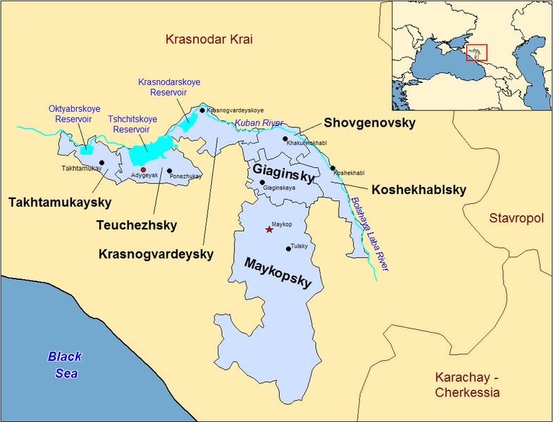
| Disgrifiad | Map of the districts of the Adygea republic of Russia. Created by Rarelibra 13:10, 30 March 2007 (UTC) for public domain use, using MapInfo Professional v8.5 and various mapping resources. |
| Dyddiad | 30 Mawrth 2007 (original upload date) |
| Ffynhonnell | No machine-readable source provided. Own work assumed (based on copyright claims). |
| Awdur | No machine-readable author provided. Rarelibra assumed (based on copyright claims). |
Previous summary and history (en.wikipedia)
Map of the districts of the Republic of Adygea (federal subject of Russia). Created by Rarelibra 20:52, 20 December 2006 (UTC) for public domain use, using MapInfo Professional v8.5 and various mapping resources. Special thanks to w:User:Ezhiki for both his patience and input to help complete this map for his wiki project.
- 16:06, April 3, 2007 . . Rarelibra (Talk | contribs | block) . . 1056×816 (58,397 bytes) (Updated version)
- 17:35, March 27, 2007 . . Rarelibra (Talk | contribs | block) . . 823×752 (50,852 bytes) (Updated map)
- 22:34, December 20, 2006 . . Rarelibra (Talk | contribs | block) . . 1281×878 (48,913 bytes) (Map of the districts of the Republic of Adygea (a federal subject of Russia). Created by ~~~~ for public domain use with attribution under GNU. Created using MapInfo Professional v8.5 and various mapping resources. Special thanks to User:Ezhiki for hi)
- 20:52, December 20, 2006 . . Rarelibra (Talk | contribs | block) . . 1281×878 (43,557 bytes) (Map of the districts of the Republic of Adygea (federal subject of Russia). Created by ~~~~ for public domain use, using MapInfo Professional v8.5 and various mapping resources. Special thanks to User:Ezhiki for both his patience and input to help com)
Trwyddedu
| Yr wyf fi, deiliad hawlfraint y gwaith hwn, yn ei ryddhau i'r parth cyhoeddus, a hynny'n fyd-eang. Hwyrach nad yw hyn yn bosib yn ôl cyfraith rhai gwledydd; os felly: Rwyn rhoi i unrhywun yr hawl i ddefnyddio'r gwaith hwn at unrhyw ddiben, heb unrhyw amodau, oddieithr unrhyw amodau gofynnol yn ôl y gyfraith. |
Hanes y ffeil
Cliciwch ar ddyddiad / amser i weld y ffeil fel ag yr oedd bryd hynny.
| Dyddiad / Amser | Bawdlun | Hyd a lled | Defnyddiwr | Sylw | |
|---|---|---|---|---|---|
| cyfredol | 22:53, 31 Rhagfyr 2023 | | 1,013 × 774 (56 KB) | User-duck | Cropped border using CropTool with lossless mode. |
| 13:18, 23 Ebrill 2007 |  | 1,056 × 816 (57 KB) | Rarelibra | Reverted to earlier revision | |
| 15:54, 21 Ebrill 2007 |  | 1,056 × 816 (46 KB) | David Kernow~commonswiki | ||
| 16:04, 3 Ebrill 2007 |  | 1,056 × 816 (57 KB) | Rarelibra | Updated version | |
| 13:10, 30 Mawrth 2007 |  | 823 × 752 (50 KB) | Rarelibra | Map of the districts of the Adygea republic of Russia. Created by ~~~~ for public domain use, using MapInfo Professional v8.5 and various mapping resources. |
Cysylltiadau'r ffeil
Mae'r 1 tudalennau a ddefnyddir isod yn cysylltu i'r ddelwedd hon:
Defnydd cydwici y ffeil
Mae'r wicis eraill hyn yn defnyddio'r ffeil hon:
- Y defnydd ar af.wikipedia.org
- Y defnydd ar azb.wikipedia.org
- Y defnydd ar ca.wikipedia.org
- Y defnydd ar de.wikipedia.org
- Y defnydd ar el.wikipedia.org
- Y defnydd ar en.wikipedia.org
- Y defnydd ar fa.wikipedia.org
- Y defnydd ar fi.wikipedia.org
- Y defnydd ar frr.wikipedia.org
- Y defnydd ar fr.wikipedia.org
- Y defnydd ar incubator.wikimedia.org
- Y defnydd ar io.wikipedia.org
- Y defnydd ar it.wikipedia.org
- Y defnydd ar krc.wikipedia.org
- Y defnydd ar lv.wikipedia.org
- Y defnydd ar mn.wikipedia.org
- Y defnydd ar nl.wikipedia.org
- Y defnydd ar pl.wikipedia.org
- Y defnydd ar pl.wiktionary.org
- Y defnydd ar pt.wikipedia.org
- Y defnydd ar ru.wikivoyage.org